


NWS Memphis - 2014 Annual Climate Summary |
Another year has come and gone, with 365 days of weather added to the history books to create the overall climate of 2014. The
year 2014 continued the cooler and wetter trend that began during 2013, with all four official sites reporting cooler than
normal average temperatures for the year, and all sites except Jonesboro receiving more precipitation than normal. The year
2014 was cool enough to set a new record for the coolest year on record at Jackson, while being the 7th coolest on
record at Tupelo. Annual average temperatures were cooler this year when compared to 2013, thanks in part to a very cool
November that experienced average temperatures for the month that were nearly 6 degrees below normal, making it the month with
the greatest temperature departures from normal. The region also experienced an abnormally cool July, normally one of the
warmest months of the year, with the month being the coolest July on record at all sites except Memphis, where it was the
6th coolest. Normally the month of June is around three degrees cooler than July, but this year June was actually a
couple of degrees warmer than July. This displays the abnormality of July 2014 in regards to temperature.
Memphis reached 100 degrees during 2014, a temperature not reached at all in the city the previous year. This was the warmest temperature recorded of the four official sites this year, while Jackson recorded the coolest temperature of the year with 0 degrees. Overall, Memphis was the warmest site with an average temperature of 61.4 degrees, a 1.7 degree departure below normal. This made 2014 the coolest year since 1997 in Memphis, and tied with several other years for the 15th coolest year on record. Jackson recorded an average temperature of 58.1 degrees, also a 1.7 degree departure below normal. Jonesboro had the greatest departure from normal for the year at 2.0 degrees cooler than normal with an average temperature of 58.0 degrees. Finally, Tupelo had an average temperature of 60.9 degrees, which was 1.6 degrees cooler than normal.
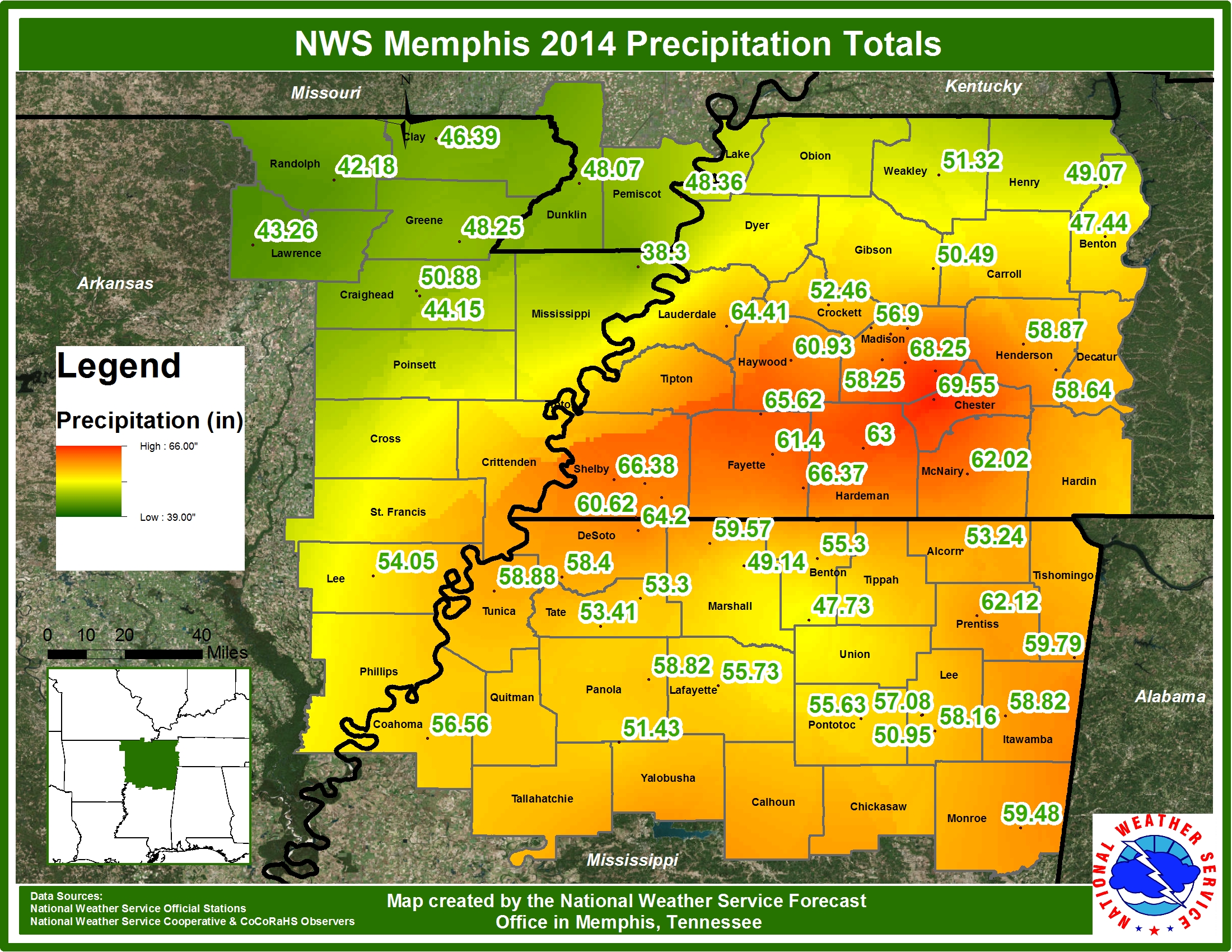
One of the biggest weather stories from around the region this past year was the heavy rain and flash flooding that occurred in Memphis on June 29th and again on September 11th. 5.87 inches of rain fell on June 29th, while 4.45 inches of rain fell on September 11th. This made June 29th the wettest day of the year for Memphis and aided June in being the wettest month of the year and the 2nd wettest June on record for the city. The rainfall from June 29th and September 11th combined accounted for 18 percent of Memphis' precipitation total for the year. Despite receiving 57.63 inches of precipitation and being 3.95 inches above normal for the year at Memphis, the wettest site was actually Jackson with 58.28 inches of precipitation, which was 5.01 inches above normal. Tupelo received 57.09 inches of precipitation over the year, a departure of 2.08 inches above normal, while Jonesboro received only 44.15 inches and had the only negative departure for the year with 3.95 inches below normal.
There was not much snow to be found around the region this year, with all four sites reporting below normal snowfall totals. Jonesboro received the most snow with 4.5 inches of snowfall, which was only 0.3 inches below normal. Much of Jonesboro's snow fell on March 2nd and 3rd when 3.2 inches was reported. This was also the event with the greatest snow depth of the year, with 3 inches of snow on the ground at Jonesboro on the mornings of March 3rd and 4th. Jackson received 1.4 inches of snow throughout the year, a 3.2 inch departure below normal. The snowiest day there was March 3rd with 0.8 inches reported, while the days with the greatest snow depth of 1 inch were March 3rd and 5th. Memphis received 1.0 inch of snow this year, a 2.8 inch departure below normal. The greatest snow depth was also 1 inch and was reported on the morning of March 4th. Tupelo received all of its snow on one day, February 11th, with 0.5 inches, a 1.6 inch departure below normal.
Finally, the last freeze of the 2013-2014 winter season occurred around the last week of March through the first week of April for most areas, with Memphis' latest being the earliest of all four sites on March 24th. Conversely, the earliest freeze of the 2014-2015 winter season occurred around the first week of November. Memphis' earliest freeze was the latest of all sites, occurring on November 12th.
The chart below contains significant climate data for the four official reporting sites across the Mid-South during the year 2014.
Notable Statistics
There was no shortage of notable statistics during 2014, mostly due to the abnormal cool months (July and November in particular). The most impressive include the month of June ranking in the top ten wettest months of June for all four sites (and it was the 8th wettest month ever on record at Memphis), and the coolest July on record for all sites except Memphis (where it was the 6th). November made the top ten coolest months of November as 2nd, 3rd, and 4th for Jackson, Jonesboro, and Tupelo, respectively. 2014 was the coolest year on record at Jackson (tied with 1979), while it was the 7th coolest at Tupelo. It should be noted that these sites have shorter records when compared to Memphis and Jonesboro which could help explain why the latter two sites did not see 2014 rank in the top ten coolest years.
The full list of notable statistics:
MEMPHIS
#2 Wettest June on Record with 13.40"
#6 Coolest July on Record at 78.0°F
#7 Wettest Day on Record with 5.87" (June 29th)
#8 Wettest Month on Record with 13.40" (June)
JACKSON
#1 Coolest Year on Record at 58.1°F (tied 1979)
#1 Wettest June on Record at 12.57"
#1 Coolest July on Record at 74.1°F
#2 Coolest November on Record at 44.1°F
#6 Coolest January on Record at 32.6°F
#6 Wettest Month on Record with 12.57" (June)
#7 Coolest March on Record at 45.5°F
#9 Coolest February on Record at 38.2°F
JONESBORO
#1 Coolest July on Record at 75.3°F
#3 Wettest June on Record with 8.84"
#3 Coolest November on Record at 44.2°F
#6 Coolest March on Record at 44.3°F
#9 Coolest January on Record at 33.0°F
TUPELO
#1 Driest January on Record with 1.77"
#1 Coolest July on Record at 76.5°F
#4 Coolest November on Record at 46.8°F
#5 Wettest October on Record with 8.34"
#7 Coolest Year on Record at 60.9°F
#7 Wettest June on Record with 8.34"
#8 Coolest January on Record at 35.3°F
#10 Driest March on Record with 3.08"
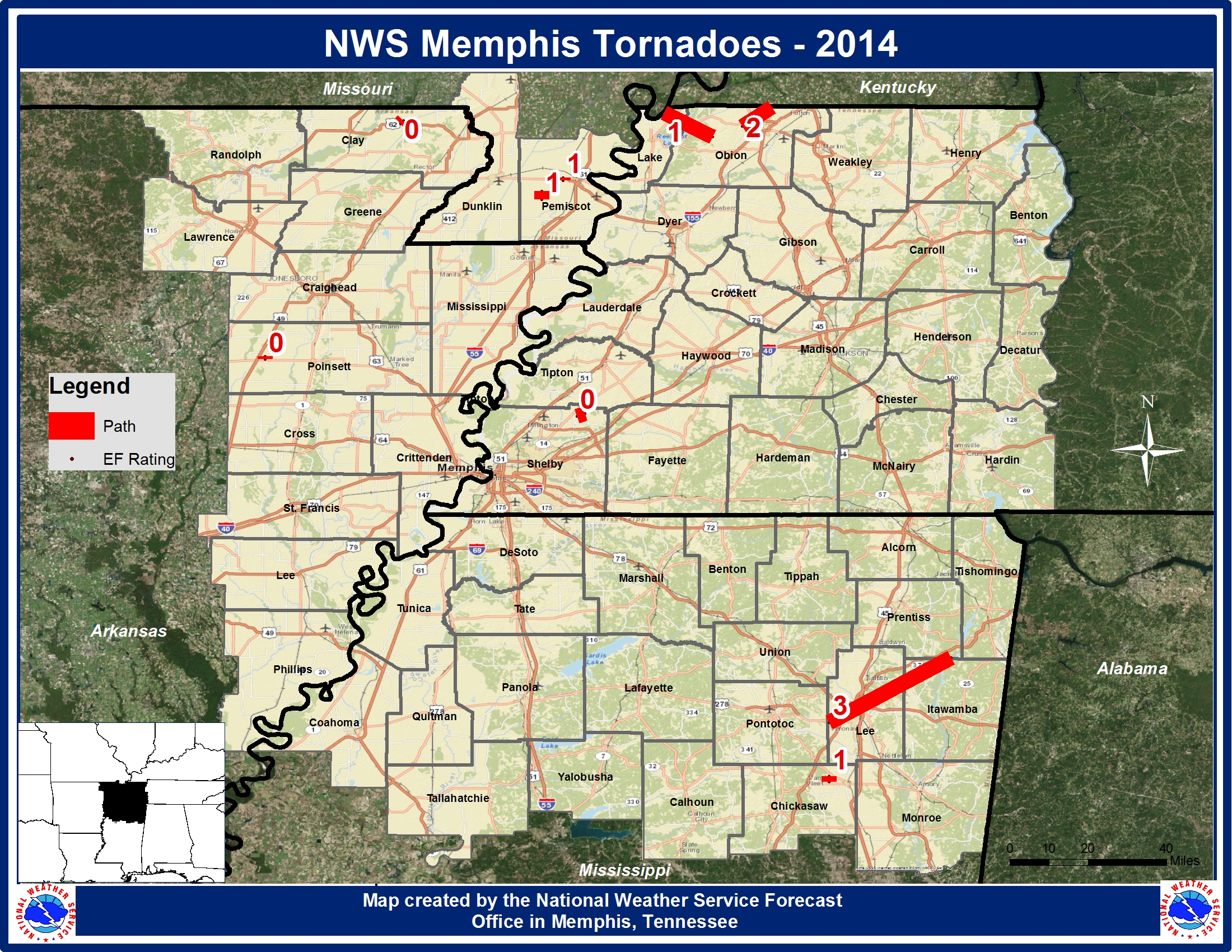
Severe Weather 2014 was a relatively quiet year in regards to severe weather. In fact, only 9 tornadoes occurred this year, and normally around 16 tornadoes occur in a year across the region. The strongest of the 9 was an EF3 that touched down in Lee County, MS and traveled almost 31 miles to end in Prentiss County, MS. This is the tornado that impacted the city of Tupelo, causing damage and injuring several. The next strongest tornado occurred on the same day as an EF2 in Obion County, TN. There were also four EF1 tornadoes and three EF0 tornadoes during 2014. No tornado-related deaths occurred in 2014.
A list of all 9 tornadoes verified in the MEG CWA with the date/time of occurrence, intensity (EF) rating and the location are listed below.
Memphis reached 100 degrees during 2014, a temperature not reached at all in the city the previous year. This was the warmest temperature recorded of the four official sites this year, while Jackson recorded the coolest temperature of the year with 0 degrees. Overall, Memphis was the warmest site with an average temperature of 61.4 degrees, a 1.7 degree departure below normal. This made 2014 the coolest year since 1997 in Memphis, and tied with several other years for the 15th coolest year on record. Jackson recorded an average temperature of 58.1 degrees, also a 1.7 degree departure below normal. Jonesboro had the greatest departure from normal for the year at 2.0 degrees cooler than normal with an average temperature of 58.0 degrees. Finally, Tupelo had an average temperature of 60.9 degrees, which was 1.6 degrees cooler than normal.
One of the biggest weather stories from around the region this past year was the heavy rain and flash flooding that occurred in Memphis on June 29th and again on September 11th. 5.87 inches of rain fell on June 29th, while 4.45 inches of rain fell on September 11th. This made June 29th the wettest day of the year for Memphis and aided June in being the wettest month of the year and the 2nd wettest June on record for the city. The rainfall from June 29th and September 11th combined accounted for 18 percent of Memphis' precipitation total for the year. Despite receiving 57.63 inches of precipitation and being 3.95 inches above normal for the year at Memphis, the wettest site was actually Jackson with 58.28 inches of precipitation, which was 5.01 inches above normal. Tupelo received 57.09 inches of precipitation over the year, a departure of 2.08 inches above normal, while Jonesboro received only 44.15 inches and had the only negative departure for the year with 3.95 inches below normal.
There was not much snow to be found around the region this year, with all four sites reporting below normal snowfall totals. Jonesboro received the most snow with 4.5 inches of snowfall, which was only 0.3 inches below normal. Much of Jonesboro's snow fell on March 2nd and 3rd when 3.2 inches was reported. This was also the event with the greatest snow depth of the year, with 3 inches of snow on the ground at Jonesboro on the mornings of March 3rd and 4th. Jackson received 1.4 inches of snow throughout the year, a 3.2 inch departure below normal. The snowiest day there was March 3rd with 0.8 inches reported, while the days with the greatest snow depth of 1 inch were March 3rd and 5th. Memphis received 1.0 inch of snow this year, a 2.8 inch departure below normal. The greatest snow depth was also 1 inch and was reported on the morning of March 4th. Tupelo received all of its snow on one day, February 11th, with 0.5 inches, a 1.6 inch departure below normal.
Finally, the last freeze of the 2013-2014 winter season occurred around the last week of March through the first week of April for most areas, with Memphis' latest being the earliest of all four sites on March 24th. Conversely, the earliest freeze of the 2014-2015 winter season occurred around the first week of November. Memphis' earliest freeze was the latest of all sites, occurring on November 12th.
The chart below contains significant climate data for the four official reporting sites across the Mid-South during the year 2014.
| Climate Data | Memphis | Jackson | Jonesboro | Tupelo | Bruceton* |
| Highest Temperature (°F) | 100 on 8/24 | 95 on 8/24 | 98 on 8/23 | 97 on 8/22 & 23 | 95 on 8/06 |
| Lowest Temperature (°F) | 8 on 1/17 | 0 on 1/29 | 4 on 1/29 | 6 on 1/24 & 23 | 2 on 1/29 |
| Average Temperature (°F) | 61.4 | 58.1 | 58.0 | 60.9 | 57.8 |
| Normal Temperature (°F) | 63.1 | 59.8 | 60.0 | 62.5 | 60.0 |
| Departure from Normal (°F) | -1.7 | -1.7 | -2.0 | -1.6 | -2.2 |
| Wettest Day | 5.78" on 6/29 | 2.81" on 6/09 | 1.97" on 4/28 | 4.61" on 7/18 | 5.54" on 6/05 |
| Total Precipitation (inches) | 57.63" | 58.28" | 44.15" | 57.09" | 58.37" |
| Normal Precipitation (inches) | 53.68" | 53.27" | 48.10" | 55.01" | 54.00 |
| Departure from Normal (inches) | +3.95" | +5.01" | -3.95" | +2.08" | +4.37 |
| Total Snowfall (inches) | 1.0" | 1.4" | 4.5" | 0.5" | 1.4" |
| Departure from Normal (inches) | -2.8" | -3.2" | -0.3" | -1.6" | -3.2 |
| Greatest Snow Depth (inches) | 1" on 3/4 | 1" on 3/3 & 5 | 3" on 3/3 & 4 | 1" on 2/11 | 1" on 3/3 |
| Earliest Freeze | 11/12 | 10/29 | 11/02 | 10/28 | 12/10 |
| Latest Freeze | 03/24 | 04/03 | 04/02 | 04/03 | 04/16 |
| Average Wind Speed (MPH) | 7.8 | 6.3 | 7.5 | 6.3 | 6.3 |
| * BRUCETON NUMBERS ARE NOT CERTIFIED BY THE MEMPHIS NWS. THESE NUMBERS ARE EXTRAPOLATED FROM DATA GATHERED FROM THE K3JAE'S WEATHER STATION. AVERAGES ARE BASED ON A TWO YEAR AVERAGE STARTING FROM 2013 AND 2014. | |||||
Notable Statistics
There was no shortage of notable statistics during 2014, mostly due to the abnormal cool months (July and November in particular). The most impressive include the month of June ranking in the top ten wettest months of June for all four sites (and it was the 8th wettest month ever on record at Memphis), and the coolest July on record for all sites except Memphis (where it was the 6th). November made the top ten coolest months of November as 2nd, 3rd, and 4th for Jackson, Jonesboro, and Tupelo, respectively. 2014 was the coolest year on record at Jackson (tied with 1979), while it was the 7th coolest at Tupelo. It should be noted that these sites have shorter records when compared to Memphis and Jonesboro which could help explain why the latter two sites did not see 2014 rank in the top ten coolest years.
The full list of notable statistics:
MEMPHIS
#2 Wettest June on Record with 13.40"
#6 Coolest July on Record at 78.0°F
#7 Wettest Day on Record with 5.87" (June 29th)
#8 Wettest Month on Record with 13.40" (June)
JACKSON
#1 Coolest Year on Record at 58.1°F (tied 1979)
#1 Wettest June on Record at 12.57"
#1 Coolest July on Record at 74.1°F
#2 Coolest November on Record at 44.1°F
#6 Coolest January on Record at 32.6°F
#6 Wettest Month on Record with 12.57" (June)
#7 Coolest March on Record at 45.5°F
#9 Coolest February on Record at 38.2°F
JONESBORO
#1 Coolest July on Record at 75.3°F
#3 Wettest June on Record with 8.84"
#3 Coolest November on Record at 44.2°F
#6 Coolest March on Record at 44.3°F
#9 Coolest January on Record at 33.0°F
TUPELO
#1 Driest January on Record with 1.77"
#1 Coolest July on Record at 76.5°F
#4 Coolest November on Record at 46.8°F
#5 Wettest October on Record with 8.34"
#7 Coolest Year on Record at 60.9°F
#7 Wettest June on Record with 8.34"
#8 Coolest January on Record at 35.3°F
#10 Driest March on Record with 3.08"
Severe Weather 2014 was a relatively quiet year in regards to severe weather. In fact, only 9 tornadoes occurred this year, and normally around 16 tornadoes occur in a year across the region. The strongest of the 9 was an EF3 that touched down in Lee County, MS and traveled almost 31 miles to end in Prentiss County, MS. This is the tornado that impacted the city of Tupelo, causing damage and injuring several. The next strongest tornado occurred on the same day as an EF2 in Obion County, TN. There were also four EF1 tornadoes and three EF0 tornadoes during 2014. No tornado-related deaths occurred in 2014.
A list of all 9 tornadoes verified in the MEG CWA with the date/time of occurrence, intensity (EF) rating and the location are listed below.
| Date | Time (CST) | EF Rating | Location |
| Feb 20 | 1639 | EF1 | Pemiscot County, MO (0.7 S Deering) |
| Feb 20 | 1641 | EF1 | Pemiscot County, MO (2.1 WSW Hayti HGTS) |
| Apr 28 | 0546 | EF0 | Shelby County, TN (1.9 ESE Rosemark) |
| Apr 28 | 1338 | EF3 | Lee County, MS to Prentiss County, MS |
| Apr 28 | 1718 | EF2 | Obion County, TN (5 W Union City) |
| Jun 7 | 1412 | EF1 | Lake County, TN to Obion County, TN |
| Jun 12 | 2130 | EF1 | Chickasaw County, MS (4.5 WNW Okolona) |
| Oct 2 | 2028 | EF0 | Poinsett County, AR (0.6 SSW Weiner Muni Arpt) |
| Oct 13 | 1148 | EF0 | Clay County, AR (1.2 WNW McDougal) |

