


What is a Nor'easter? |
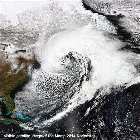 A Nor'easter is a macro-scale cyclone. The name derives from the direction of the strongest winds - as an offshore air mass rotating
counterclockwise, winds tend to blow northeast-to-southwest over the region covered by the northwest quadrant of the cyclone. Use of
the term in North America is associated with several different types of storms, some of which can form in the North Atlantic Ocean and some
of which form as far south as the Gulf of Mexico. The term is most often used in the coastal areas of New England and the Mid-Atlantic states.
Typically, such storms originate as a low-pressure area that forms within 100 miles (160 km) east or west of the East Coast in the latitudes
between Georgia and New Jersey. The precipitation pattern is similar to that of other extratropical storms. Nor'easters are usually accompanied
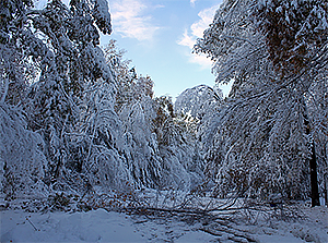
by very heavy rain or snow, and can cause severe coastal flooding, coastal erosion, hurricane-force winds, or blizzard conditions. Nor'easters
are usually most intense during winter in New England and Atlantic Canada. They thrive on converging air masses - the cold polar air mass and the
warmer air over the water - and are more severe in winter when the difference in temperature between these air masses is greater.
A Nor'easter is a macro-scale cyclone. The name derives from the direction of the strongest winds - as an offshore air mass rotating
counterclockwise, winds tend to blow northeast-to-southwest over the region covered by the northwest quadrant of the cyclone. Use of
the term in North America is associated with several different types of storms, some of which can form in the North Atlantic Ocean and some
of which form as far south as the Gulf of Mexico. The term is most often used in the coastal areas of New England and the Mid-Atlantic states.
Typically, such storms originate as a low-pressure area that forms within 100 miles (160 km) east or west of the East Coast in the latitudes
between Georgia and New Jersey. The precipitation pattern is similar to that of other extratropical storms. Nor'easters are usually accompanied
by very heavy rain or snow, and can cause severe coastal flooding, coastal erosion, hurricane-force winds, or blizzard conditions. Nor'easters
are usually most intense during winter in New England and Atlantic Canada. They thrive on converging air masses - the cold polar air mass and the
warmer air over the water - and are more severe in winter when the difference in temperature between these air masses is greater.It's unclear whether dropping the letters "th" in "northeaster" is a regional affectation or a legacy term used in maritime compass reading. Despite the best efforts of those who wished an end to the contraction, including the late Maine resident Edgar Comee, it remains a popular term. Whenever Comee came across a "Nor'easter," whether televised or printed, he fired off a postcard of complaint. According to Comee, a retired Navy sea captain, "the use of a Nor'easter to describe a northeast storm is ... the odious, even loathsome, practice of landlubbers who would be seen as salty as the sea itself." [source: McGrath].
These storms progress generally northeastward and typically attain maximum intensity near New England and the Maritime Provinces of Canada. They nearly always bring precipitation in the form of heavy rain or snow, as well as winds of gale force, rough seas, and, occasionally, coastal flooding to the affected regions. The heavily populated region between Washington D.C., Philadelphia, New York and Boston also known as the "I-95 Corridor," is especially impacted by Nor'easters.
These storms may occur at any time of year but are most frequent and most violent between September and April. Some well known Nor'easters include the notorious Blizzard of 1888, the "Ash Wednesday" storm of March 1962, the New England Blizzard of February 1978, the "March 1993 Superstorm" and the most recently notable, Boston snowstorms of January and February 2015. Past Nor'easters have been responsible for billions of dollars in damage, severe economic, transportation and human disruption, and in some cases, disastrous coastal flooding. Damage from the worst storms can exceed a billion dollars.
The U.S. East Coast provides an ideal breeding ground for Nor'easters. During winter. The polar jet stream transports cold Arctic air southward across the plains of Canada and the United States, then eastward towards the Atlantic Ocean where warm air from the Gulf of Mexico and the Atlantic tries to move northward. The warm waters of the Gulf Stream help keep the coastal waters relatively mild during the winter, which in turn helps warm the cold winter air over the water. This difference in temperature between the warm air over the water and cold Arctic air over the land is the fuel that feeds Nor'easters.
Nor'easters are usually formed by an area of vorticity associated with an upper-level disturbance or from a kink in a frontal surface that causes a surface low-pressure area to develop. Such storms are very often formed from the merging of several weaker storms, a "parent storm", and a polar jet stream mixing with the tropical jet stream.
Until the Nor'easter passes, thick, dark, low-level clouds often block out the sun. Temperatures usually fall significantly due to the presence of the cooler air from winds that typically come from a northeasterly direction. During a single storm, the precipitation can range from a torrential downpour, a very heavy snowfall, to a fine mist. All precipitation types can occur in a Nor'easter. High wind gusts, which can reach hurricane levels, are also associated with a Nor'easter. On very rare occasions, such as in the North American blizzard of 2006 and a Nor'easter in 1978, the center of the storm can take on the circular shape more typical of a hurricane and have a small "dry slot" near the center, which can be mistaken for an eye, although it is not an eye.
Weather forecasters at NWS local forecast offices around the country and at the National Centers for Environmental Prediction near Washington, D.C., monitor conditions conducive for Nor'easters, especially during the fall and winter. When they see conditions are favorable in the upcoming days, forecasters may issue winter storm, blizzard, high wind and coastal flood watches to alert the public that some of the worst effects of Nor'easters may be possible. If conditions are imminent, those watches are changed to warnings.
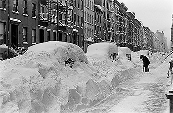
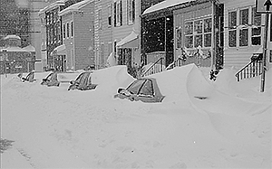 If a Nor'easter threatens your home town, take steps to prepare, such as having at least three days of food, water and other provisions in a disaster
supplies kit to include plenty of extra, fresh batteries, working flashlights, extra blankets, first aid medical supplies, needed prescriptions, a small
portable radio and any other items deemed necessary to sustain life. A Nor'easter could cut power and leave you in the dark. Additionally it is extremely
wise to sit down with your family and create an emergency communications plan so your loved ones know how to stay in touch if you are separated. This is
especially true if you reside in an area were this weather phenomena is prevalent. Please stay off the roads if advised by local authorities to avoid
traveling and never ever drive into flood waters. These simple actions will assist you and your family in staying safe during a Nor'easter.
If a Nor'easter threatens your home town, take steps to prepare, such as having at least three days of food, water and other provisions in a disaster
supplies kit to include plenty of extra, fresh batteries, working flashlights, extra blankets, first aid medical supplies, needed prescriptions, a small
portable radio and any other items deemed necessary to sustain life. A Nor'easter could cut power and leave you in the dark. Additionally it is extremely
wise to sit down with your family and create an emergency communications plan so your loved ones know how to stay in touch if you are separated. This is
especially true if you reside in an area were this weather phenomena is prevalent. Please stay off the roads if advised by local authorities to avoid
traveling and never ever drive into flood waters. These simple actions will assist you and your family in staying safe during a Nor'easter.NOTABLE OR HISTORIC NOR'EASTERNS
The most recent memorable and historical Nor'easterns on record and which are still considered to be the worst in recorded history, to date, is actually a toss-up between the East Coast Blizzard of 1996 and the The Blizzard of 2003, also known as the Presidents' Day Storm II. Both of these storms had eerily similar tracks with near similar snowfall amounts occurring in the same locations.
2011 HALLOWEEN NOR'EASTERN
The 2011 Halloween Nor'easter, sometimes referred to as "Snowtober", was a large low pressure area that produced unusually early snowfall across the northeastern United States and the Canadian Maritimes. The storm arrived just two months after Hurricane Irene caused extensive power outages and property damage in the Northeast; with the 2011 New England tornado outbreak also causing damage in Western Massachusetts.
Early on 28 October 2011, a ridge over Canada advected an unseasonably cold air mass across the Mid-Atlantic states and New England; at the same time, a surface low-pressure area began developing along the coast of Louisiana. A cold front moved eastward from the Ohio Valley and exited the East Coast of the United States, developing another low pressure area off the coast of the Carolinas on 29 October. The remnants of Hurricane Rina had also been absorbed into the developing system. At the same time, an area of precipitation extended from South Carolina through Pennsylvania, mostly falling as rain with some snow observed at higher elevations. By late that morning, the system was producing precipitation over much of the Mid-Atlantic and New England.
As the system moved to the northeast through the day, it produced widespread snow and winds near hurricane-strength north of the cyclone's warm front over the open waters of the Atlantic Ocean. its associated snowfall broke records in at least 20 cities for total accumulations, resulting in a rare "white Halloween" two days later. Winds as high as 69 mph (111 km/h) were observed in Massachusetts, and the National Weather Service, issued a Hurricane Force Wind Warning for the Gulf of Maine and other high seas off New England. Overnight into 30 October, the storm passed south of Nantucket, and it moved over Nova Scotia later that day with a barometric pressure of 975 mb (28.8 inHg). As it did so, the associated precipitation diminished over New England and moved into Atlantic Canada. As the system moved out into the Atlantic Ocean, it reached a minimum barometric pressure of 971 mb (28.7 inHg) as it passed to the east of the island of Newfoundland late on 31 October. By the early morning of 01 November, the system had fully moved out to sea. The storm then hit the UK as Cyclone Quinn.
BLIZZARD OF 2003
The Blizzard of 2003 developed in the southern Rockies on 14 February and lasted until 19 February 2003, and moved through southern Missouri and the Lower Tennessee Valley during the next few days. It brought heavy rain, ice and severe weather to some areas of the South, including the nation's first tornado of the year (F0 - 15 February 2003 at 4:20 pm just north of Puckitt, MS.) and spawned a total of 16 more, the most damaging being an F2 on 22 February 2003 at 9:18 am, about halfway between Evans, GA and Pollards Corner, GA.
 Farther north, snow and ice affected the Midwest. Southern Iowa and eastern Illinois also got significant snow, with 11 inches (28 cm) in Des Moines. In central
Kentucky the storm produced mostly ice, with some locations including Frankfort, Lexington, and nearby Cynthiana in Harrison County receiving up to 3/4" (2 cm)
of ice. Also the deadliest tornado, an F1, developed on 22 February 2003 at 3:09 pm in Breathitt County, KY where 2 lives were lost. Much of Ohio received heavy
snowfall, with Mansfield, OH receiving 21 inches and Columbus, OH receiving about a foot.
Farther north, snow and ice affected the Midwest. Southern Iowa and eastern Illinois also got significant snow, with 11 inches (28 cm) in Des Moines. In central
Kentucky the storm produced mostly ice, with some locations including Frankfort, Lexington, and nearby Cynthiana in Harrison County receiving up to 3/4" (2 cm)
of ice. Also the deadliest tornado, an F1, developed on 22 February 2003 at 3:09 pm in Breathitt County, KY where 2 lives were lost. Much of Ohio received heavy
snowfall, with Mansfield, OH receiving 21 inches and Columbus, OH receiving about a foot.The severity of the Blizzard of 2003 can be attributed to the unusually favorable atmospheric conditions surrounding the storm (synoptic conditions). Most notably, the storm allowed for cyclogenesis off of the coastal Carolinas, a feature that is common to most major winter storms in the eastern parts of North America. This secondary system fed off the moisture of the Atlantic Ocean and enhanced precipitation totals from North Carolina to Massachusetts. Secondly, a high pressure system was in place over eastern portions of Canada, allowing for cold air to be brought down into the coastal areas in a process known as cold air advection. This cold air ensured that many of the areas where generally storms typically produce mixed precipitation would receive most or all precipitation in the form of snow. this storm received an RSI rating of Category 4 "Crippling" (RSI: 14.53).
BLIZZARD OF 1996 (AKA Presidents' Day Storm II)
The East Coast Blizzard of 1996 was a severe Nor'easter that paralyzed the U.S. East Coast with up to 4 feet (1.2 m) of wind-driven snow lasting from 6 January to 8 January 1996. This was followed by another storm, an Alberta Clipper, on 12 January, where unusually warm weather and torrential rain caused rapid snow melting and river flooding. This along with the March Superstorm of 1993 (also known as the 1993 Storm of the Century (not classified as a Nor'eastern since it was a large cyclonic storm that formed over the Gulf of Mexico on 12 March 1993)) resulted in the East Coast Blizzard of 1996 to become one of only two snowstorms to receive the top rating of 5, or "Extreme", on the Northeast Snowfall Impact Scale (NESIS) and the Regional Snowfall Index receiving an RSI of 20.66, tied for 9th highest RSI on record of any storm.
1991 PERFECT STORM
 The 1991 Perfect Storm, also known as the The No-Name Storm (especially in the years immediately after it took place) and the Halloween Gale,
was a Nor'easter that absorbed Hurricane Grace and ultimately evolved back into a small unnamed hurricane late in its life cycle. The initial area of low pressure
developed off Atlantic Canada on 29 October. Forced southward by a ridge to its north, it reached its peak intensity as a large and powerful cyclone. The storm
lashed the east coast of the United States with high waves and coastal flooding before turning to the southwest and weakening. Moving over warmer waters, the
system transitioned into a subtropical cyclone before becoming a tropical storm. It executed a loop off the Mid-Atlantic states and turned toward the northeast.
On 01 November the system evolved into a full-fledged hurricane with peak winds of 75 miles per hour (120 km/h), although the National Hurricane Center left it
unnamed to avoid confusion amid media interest in the predecessor extratropical storm. It later received the name "the Perfect Storm" (playing off the
common expression) after a conversation between Boston National Weather Service forecaster Robert Case and author Sebastian Junger. The system was the fourth
hurricane and final tropical cyclone in the 1991 Atlantic hurricane season. The tropical system weakened, striking Nova Scotia as a tropical storm before
dissipating.
The 1991 Perfect Storm, also known as the The No-Name Storm (especially in the years immediately after it took place) and the Halloween Gale,
was a Nor'easter that absorbed Hurricane Grace and ultimately evolved back into a small unnamed hurricane late in its life cycle. The initial area of low pressure
developed off Atlantic Canada on 29 October. Forced southward by a ridge to its north, it reached its peak intensity as a large and powerful cyclone. The storm
lashed the east coast of the United States with high waves and coastal flooding before turning to the southwest and weakening. Moving over warmer waters, the
system transitioned into a subtropical cyclone before becoming a tropical storm. It executed a loop off the Mid-Atlantic states and turned toward the northeast.
On 01 November the system evolved into a full-fledged hurricane with peak winds of 75 miles per hour (120 km/h), although the National Hurricane Center left it
unnamed to avoid confusion amid media interest in the predecessor extratropical storm. It later received the name "the Perfect Storm" (playing off the
common expression) after a conversation between Boston National Weather Service forecaster Robert Case and author Sebastian Junger. The system was the fourth
hurricane and final tropical cyclone in the 1991 Atlantic hurricane season. The tropical system weakened, striking Nova Scotia as a tropical storm before
dissipating.The Perfect Storm originated from a cold front that exited the east coast of the United States. On 28 October, the front spawned an extratropical low to the east of Nova Scotia. Around that time, a ridge extended from the Appalachian Mountains northeastward to Greenland, with a strong high pressure center over eastern Canada. The blocking ridge forced the extratropical low to track toward the southeast and later to the west. Hurricane Grace was swept aloft by its cold front into the warm conveyor belt circulation of the deep cyclone on 29 October. The cyclone significantly strengthened as a result of the temperature contrast between the cold air to the northwest and the warmth and humidity from the remnants of Hurricane Grace. The low pressure system continued deepening as it drifted toward the United States. It had an unusual retrograde motion for a Nor'easter, beginning a set of meteorological circumstances that occur only once every 50 to 100 years. Most Nor'easters affect New England from the southwest.

