


Jet Streams Explained |
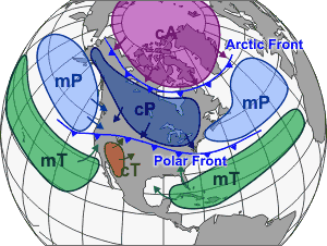 An air mass is a large body of air with generally uniform temperature and humidity. The area from which an air mass originates is called a
"source region."
An air mass is a large body of air with generally uniform temperature and humidity. The area from which an air mass originates is called a
"source region."Air mass source regions range from extensive snow covered polar areas to deserts to tropical oceans. The United States is not a favorable source region because of the relatively frequent passage of weather disturbances that disrupt any opportunity for an air mass to stagnate and take on the properties of the underlying region. The longer the air mass stays over its source region, the more likely it will acquire the properties of the surface below.
The four principal air mass classifications that influence the continental United States according to their source region are:
- Polar latitudes - Located poleward of 60° north and south.
- Continental - Located over large land masses between 25°N/S and 60°N/S.
- Maritime - Located over the oceans between 25°N/S and 60°N/S
- Tropical latitudes - Located within about 25° of the equator.
The Gulf Coast states and the eastern third of the country commonly experience the tropical air mass in the summer. Continental tropical (cT) air is dry air pumped north, off of the Mexican Plateau. If it becomes stagnant over the Midwest, a drought may result. Maritime tropical (mT) air is air from the tropics which has moved north over cooler water.
Air masses can control the weather for a relatively long time period: from a period of days, to months. Most weather occurs along the periphery of these air masses at boundaries called fronts.
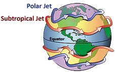
Jet streams are fast flowing, relatively narrow air currents found at the tropopause, the transition between the troposphere (where temperature decreases with height) and the stratosphere (where temperature increases with height), and are located at ~32,810 - ~50,000 ft. (10-15 kilometers) above the surface of the Earth. They form near boundaries of adjacent air masses with significant differences in temperature, such as the polar region and the warmer air to the south. The path of the jet typically has a meandering shape, and these meanders are one manifestation of Rossby waves. Rossby waves propagate westward with respect to the flow in which they are embedded, which translates to a slower eastward migration across the globe than smaller scale short wave troughs. The major jet streams are westerly winds (flowing west to east) in the Northern Hemisphere.
During the summer, easterly jets can form in tropical regions, typically in a region where dry air encounters more humid air at high altitudes. Low level jets can form wherever low level winds are squeezed together, typically between an oncoming front and a high pressure cell.
Meteorologists use the location of the jet stream as an aid in weather forecasting. The main commercial use of the jet stream is in air travel, as flight time can be dramatically affected by either flying with or against the stream. One type of clear-air turbulence is found in a jet stream's vicinity, which can be a hazard to aircraft. One future benefit of the jet stream could be to power airborne wind turbines, if technological hurdles can be overcome.
UPPER-LEVEL VARIETY
 In general, winds are strongest just under the tropopause (except during tornadoes, hurricanes or other anomalous situations). If two air masses
of different temperatures or densities meet, the resulting pressure difference caused by the density difference (which causes wind) is highest
within the transition zone. The wind does not flow directly from the hot to the cold area, but is deflected by the Coriolis effect and flows along
the boundary of the two air masses. The polar front and subtropical jets merge at some locations and times, while at other times they are well
separated.
In general, winds are strongest just under the tropopause (except during tornadoes, hurricanes or other anomalous situations). If two air masses
of different temperatures or densities meet, the resulting pressure difference caused by the density difference (which causes wind) is highest
within the transition zone. The wind does not flow directly from the hot to the cold area, but is deflected by the Coriolis effect and flows along
the boundary of the two air masses. The polar front and subtropical jets merge at some locations and times, while at other times they are well
separated.All these facts are consequences of the thermal wind relation. The balance of forces on an atmospheric parcel in the vertical direction is primarily between the pressure gradient and the force of gravity, a balance referred to as hydrostatic. In the horizontal, the dominant balance outside of the tropics is between the Coriolis effect and the pressure gradient, a balance referred to as geostrophic. Given both hydrostatic and geostrophic balance, one can derive the thermal wind relation: the vertical derivative of the horizontal wind is proportional to the horizontal temperature gradient. The sense of the relation is such that temperatures decreasing polewards implies that winds develop a larger eastward component as one moves upwards. Therefore, the strong eastward moving jet streams are in part a simple consequence of the fact that the equator is warmer than the north and south poles.
The thermal wind relation does not immediately provide an explanation for why the winds are organized in tight jets, rather than distributed more broadly over the hemisphere. There are two factors that contribute to this sharpness of the jets. One is the tendency for developing cyclonic disturbances in midlatitudes to form fronts. A front is a sharp localized gradient in temperature. The polar front jet stream can be thought of as the result of this frontogenesis process in midlatitudes, as the storms concentrate the north-south temperature contrast into relatively narrow regions.
An alternative explanation is more appropriate for the subtropical jet, which forms at the poleward limit of the tropical Hadley cell. One can visualize this circulation as being symmetric with respect to longitude. Rings of air encircling the Earth move polewards beneath the tropopause from the equator into the subtropics. As they do so they tend to conserve their angular momentum. But they are also moving closer to the axis of rotation, so they must spin faster in the direction of rotation, implying an increased eastward component of the winds.
Jupiter's atmosphere has multiple jet streams, forming the familiar banded color structure, caused by internal heating. The factors that control the number of jet streams in a planetary atmosphere is an active area of research in dynamical meteorology. In models, as one increases the planetary radius, holding all other parameters fixed, the number of jet streams increases.
OTHER JETS
There are wind maxima in the atmosphere at other levels of the atmosphere that are referred to as jets, including the mid-level African easterly jet which occurs during the Northern Hemisphere summer between 10°N and 20°N above West Africa, and the nocturnal poleward low-level jet in the Great Plains. A barrier jet in the low levels forms just upstream of mountain chains, with the mountains forcing the jet to be oriented parallel to the mountains. The mountain barrier increases the strength of the low level wind by 45 percent. The African jet stream is considered to play a crucial role in the southwest monsoon of Africa, and helps form the tropical waves which march across the tropical Atlantic and eastern Pacific oceans during the warm season. A southerly low-level jet in the Great Plains helps fuel overnight thunderstorm activity during the warm season, normally in the form of mesoscale convective systems which form during the overnight hours. A similar phenomenon develops across Australia, which pulls moisture poleward from the Coral Sea towards cut-off lows which form mainly across southwestern portions of the continent.
Why does the jet stream winds blow from west to east? The warm air rising at the equator moves towards both poles. The earth's rotation divides this circulation into three cells. The earth's rotation is responsible for the jet stream as well.
The motion of the air is not directly north and south but is affected by the momentum the air has as it moves away from the equator. The reason has to do with momentum and how fast a location on or above the Earth moves relative to the Earth's axis.
Your speed relative to the Earth's axis depends on your location. Someone standing on the equator is moving much faster than someone standing on a 45° latitude line. In the graphic (above right) the person at the position on the equator arrives at the yellow line sooner than the other two. Someone standing on a pole is not moving at all (except that he or she would be slowly spinning). The speed of the rotation is great enough to cause you to weigh one pound less at the equator than you would at the north or south pole.
The momentum the air has as it travels around the earth is conserved, which means as the air that's over the equator starts moving toward one of the poles, it keeps its eastward motion constant. The Earth below the air, however, moves slower as that air travels toward the poles. The result is that the air moves faster and faster in an easterly direction (relative to the Earth's surface below) the farther it moves from the equator.
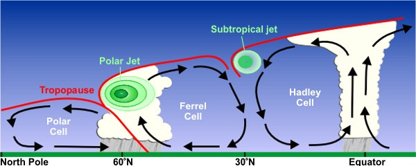
The 50°-60° N/S region is where the polar jet located with the subtropical jet located around 30°N. Jet streams vary in height of four to eight miles and can reach speeds of more than 275 mph (442.57 km/h).
The actual appearence of jet streams result from the complex interaction between many variables - such as the location of high and low pressure systems, warm and cold air, and seasonal changes. They meander around the globe, dipping and rising in altitude/latitude, splitting at times and forming eddies, and even disappearing altogether to appear somewhere else.
 Jet streams also "follow the sun" in that as the sun's elevation increases each day in the spring, the jet streams shifts north moving into Canada
by Summer. As Autumn approaches and the sun's elevation decreases, the jet stream moves south into the United States helping to bring cooler air
to the country.
Jet streams also "follow the sun" in that as the sun's elevation increases each day in the spring, the jet streams shifts north moving into Canada
by Summer. As Autumn approaches and the sun's elevation decreases, the jet stream moves south into the United States helping to bring cooler air
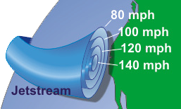
to the country.Also, the jetstream is often indicated by a line on maps and by television meteorologist. The line generally points to the location of the strongest wind. Jetstreams are typically wider and not as distinct but a region where the wind increase toward a core of strongest wind.
One way of visualizing this is consider a river. The river's current is generally the strongest in the center with decreasing strength as one approaches the river's bank. It can be said that jetstreams are "rivers of air".
EFFECTS OF ENSO
Impact of El Niño and La Niña on North AmericaMain article: Effects of the El Niño-Southern Oscillation in the United States The changing of the normal location of upper-level jet streams can be anticipated during phases of the El Niño-Southern Oscillation (ENSO), which leads to consequences precipitation-wise and temperature-wise across North America, affects tropical cyclone development across the eastern Pacific and Atlantic basins. Combined with the Pacific Decadal Oscillation, ENSO can also impact cold season rainfall in Europe. Changes in ENSO also change the location of the jet stream over South America, which partially effects precipitation distribution over the continent.
El Niño
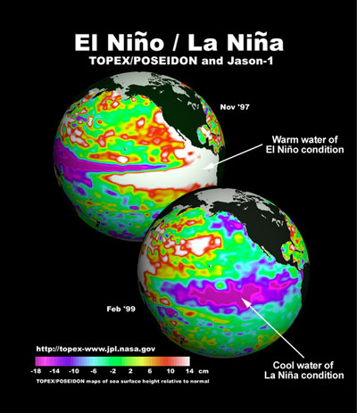 During El Niño events, increased precipitation is expected in California due to a more southerly, zonal, storm track. During the El
Niño portion of ENSO, increased precipitation falls along the Gulf coast and Southeast due to a stronger than normal, and more southerly,
polar jet stream. Snowfall is greater than average across the southern Rockies and Sierra Nevada mountain range, and is well-below normal across
the Upper Midwest and Great Lakes states. The northern tier of the lower 48 exhibits above normal temperatures during the fall and winter, while
the Gulf coast experiences below normal temperatures during the winter season. The subtropical jet stream across the deep tropics of the Northern
Hemisphere is enhanced due to increased convection in the equatorial Pacific, which decreases tropical cyclogenesis within the Atlantic tropics
below what is normal, and increases tropical cyclone activity across the eastern Pacific.In the Southern Hemisphere, the subtropical jet stream is
displaced equatorward, or north, of its normal position, which diverts frontal systems and thunderstorm complexes from reaching central portions
of the continent.
During El Niño events, increased precipitation is expected in California due to a more southerly, zonal, storm track. During the El
Niño portion of ENSO, increased precipitation falls along the Gulf coast and Southeast due to a stronger than normal, and more southerly,
polar jet stream. Snowfall is greater than average across the southern Rockies and Sierra Nevada mountain range, and is well-below normal across
the Upper Midwest and Great Lakes states. The northern tier of the lower 48 exhibits above normal temperatures during the fall and winter, while
the Gulf coast experiences below normal temperatures during the winter season. The subtropical jet stream across the deep tropics of the Northern
Hemisphere is enhanced due to increased convection in the equatorial Pacific, which decreases tropical cyclogenesis within the Atlantic tropics
below what is normal, and increases tropical cyclone activity across the eastern Pacific.In the Southern Hemisphere, the subtropical jet stream is
displaced equatorward, or north, of its normal position, which diverts frontal systems and thunderstorm complexes from reaching central portions
of the continent.La Niña
Across North America during La Niña, increased precipitation is diverted into the Pacific Northwest due to a more northerly storm track and jet stream. The storm track shifts far enough northward to bring wetter than normal conditions (in the form of increased snowfall) to the Midwestern states, as well as hot and dry summers. Snowfall is above normal across the Pacific Northwest and western Great Lakes. Across the North Atlantic, the jet stream is stronger than normal, which directs stronger systems with increased precipitation towards Europe.
JETSTREAMS POSSIBLY MOVING
Between 1979 and 2001, it has been found that the position of the jet stream has been moving northward at a rate of 1.25 miles (2.01 km) per year across the Northern Hemisphere. Across North America, this type of change could lead to drier conditions across the southern tier of the United States and more frequent and more intense tropical cyclones in the tropics. A similar slow poleward drift was found when studying the Southern Hemisphere jet stream over the same time frame.

