


STORM BASED WARNINGS |
On October 1, 2007, the NOAA National Weather Service began issuing more geographically specific warnings for tornadoes,
severe thunderstorms, flash floods and marine hazards. Previously, such warnings were issued county wide. Now, the NOAA
National Weather Service specifies areas within a specific county. These Storm Based Warnings commonly reference known
landmarks in the local area such as highways or rivers.
Why Storm Based Warnings?
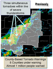
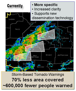
Storm Based Warnings are essential to effectively warn for severe weather. They show the specific meteorological or hydrological threat area and are not restricted to geopolitical boundaries. By focusing on the true threat area, warning polygons improve NWS warning accuracy and quality. Storm Based Warnings promote improved graphical warning displays, and in partnership with the private sector, support a wider warning distribution through cell phone alerts, pagers, and web-enabled Personal Data Assistants (PDAs). The media can display the polygons showing the public at large where the area of maximum threat is, and better depict who or what is at greatest risk.
If the typical Storm Based Warning is one-quarter the size of the typical warned county, the value of NOAA National Weather Service providing Storm Based Warnings would be almost $100 million per year in reduced cost of sheltering.I Emergency managers are able to make better decisions on what resources may be required and where. Law Enforcement and Fire Departments can know which areas need to be put on alert. Schools and businesses can more accurately determine whether they may or may not need to activate their tornado procedures and close down operations. Other government agencies and customers, such as the FAA and airlines, are able to make better risk assessments. For example, airport operators are able to better ascertain whether or not they need to temporarily shut down an airport.
Storm Based Warning Process
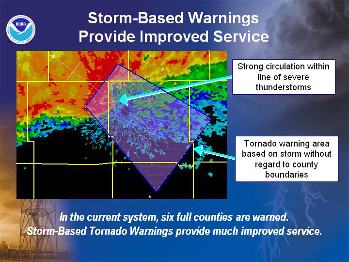
Instead of issuing warnings by county, your local NOAA National Weather Service Forecast Office are able to narrow their focus on a portion of a county (or counties) that have the greatest threat for being impacted by severe weather. The warned area is defined by latitude and longitude coordinates and depicted by polygons (as illustrated on the right). Utilizing Doppler radar, the calculated movement of severe storms can be indicated through this technique as well. All of this information is appended to the bottom of NOAA NWS Storm Based Warnings.
For audio broadcasts, portions of counties are described by compass points (e.g. northeast, south central, etc.) The use of familiar landmarks such as highways or rivers will also help describe the warned area. Warning polygons can shrink in area, but never expand. If a severe storm is expected to track outside of the current warning area, a new Storm Based Warning are issued for the region now at risk. When severe weather is no longer expected, your local NOAA National Weather Service Forecast Offices allows the warning to expire.
Short-term Challenges
With any change in service, come a few short-term challenges that must be overcome. The most significant is with Storm Based Warnings there are times where multiple warnings are in effect for the same county. This possibility must be managed with clear wording in NOAA NWS messages, and by raising the awareness of NOAA NWS customers and partners.
A second challenge is that legacy warning dissemination technologies catered to the "warning by county" culture. The advent of digital technology has, almost overnight, revolutionized communication. Storm Based Warnings, unlike textual warnings by county, meshes well with digital communication technologies such as Graphical Information Systems (GIS).
NOAA NWS Services Evolution
Storm Based Warnings is a step of NOAA NWS' Services Evolution. NOAA NWS continuously strives for improved services that will better aid society in times of high impact environmental events protecting lives, livelihoods, and your way of life. It's a vision of a science and technology based organization looking to serve America's environmental needs through thoughtful planning and effective action. Providing a better quality warning service to the public by reducing the area and number of people unnecessarily warned, is a step in the right direction.
For more information on Storm Based Warnings, please visit http://www.weather.gov/sbwarnings
IEstimates provided by Dr. Daniel S. Sutter, Associate Professor of Economics, University of Texas - Pan American
Why Storm Based Warnings?
Storm Based Warnings are essential to effectively warn for severe weather. They show the specific meteorological or hydrological threat area and are not restricted to geopolitical boundaries. By focusing on the true threat area, warning polygons improve NWS warning accuracy and quality. Storm Based Warnings promote improved graphical warning displays, and in partnership with the private sector, support a wider warning distribution through cell phone alerts, pagers, and web-enabled Personal Data Assistants (PDAs). The media can display the polygons showing the public at large where the area of maximum threat is, and better depict who or what is at greatest risk.
If the typical Storm Based Warning is one-quarter the size of the typical warned county, the value of NOAA National Weather Service providing Storm Based Warnings would be almost $100 million per year in reduced cost of sheltering.I Emergency managers are able to make better decisions on what resources may be required and where. Law Enforcement and Fire Departments can know which areas need to be put on alert. Schools and businesses can more accurately determine whether they may or may not need to activate their tornado procedures and close down operations. Other government agencies and customers, such as the FAA and airlines, are able to make better risk assessments. For example, airport operators are able to better ascertain whether or not they need to temporarily shut down an airport.
Storm Based Warning Process
Instead of issuing warnings by county, your local NOAA National Weather Service Forecast Office are able to narrow their focus on a portion of a county (or counties) that have the greatest threat for being impacted by severe weather. The warned area is defined by latitude and longitude coordinates and depicted by polygons (as illustrated on the right). Utilizing Doppler radar, the calculated movement of severe storms can be indicated through this technique as well. All of this information is appended to the bottom of NOAA NWS Storm Based Warnings.
For audio broadcasts, portions of counties are described by compass points (e.g. northeast, south central, etc.) The use of familiar landmarks such as highways or rivers will also help describe the warned area. Warning polygons can shrink in area, but never expand. If a severe storm is expected to track outside of the current warning area, a new Storm Based Warning are issued for the region now at risk. When severe weather is no longer expected, your local NOAA National Weather Service Forecast Offices allows the warning to expire.
Short-term Challenges
With any change in service, come a few short-term challenges that must be overcome. The most significant is with Storm Based Warnings there are times where multiple warnings are in effect for the same county. This possibility must be managed with clear wording in NOAA NWS messages, and by raising the awareness of NOAA NWS customers and partners.
A second challenge is that legacy warning dissemination technologies catered to the "warning by county" culture. The advent of digital technology has, almost overnight, revolutionized communication. Storm Based Warnings, unlike textual warnings by county, meshes well with digital communication technologies such as Graphical Information Systems (GIS).
NOAA NWS Services Evolution
Storm Based Warnings is a step of NOAA NWS' Services Evolution. NOAA NWS continuously strives for improved services that will better aid society in times of high impact environmental events protecting lives, livelihoods, and your way of life. It's a vision of a science and technology based organization looking to serve America's environmental needs through thoughtful planning and effective action. Providing a better quality warning service to the public by reducing the area and number of people unnecessarily warned, is a step in the right direction.
For more information on Storm Based Warnings, please visit http://www.weather.gov/sbwarnings
IEstimates provided by Dr. Daniel S. Sutter, Associate Professor of Economics, University of Texas - Pan American

