


CoCoRaHS |
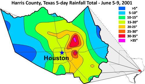 In June 2001, Tropical Storm Allison deposited a tremendous amount of rain in southeast Texas. In Harris County alone, up to three feet of rain
fell near Houston, Texas during a 5-day period. The map (right) of Harris County shows the rainfall distribution. The difference in rain across
the county ranged from less than 5 inches (127 mm) to nearly 37 inches (940 mm).
In June 2001, Tropical Storm Allison deposited a tremendous amount of rain in southeast Texas. In Harris County alone, up to three feet of rain
fell near Houston, Texas during a 5-day period. The map (right) of Harris County shows the rainfall distribution. The difference in rain across
the county ranged from less than 5 inches (127 mm) to nearly 37 inches (940 mm).Large differences in rainfall amounts are more common than one would normally expect. But often these large differences are not seen in the rainfall data due to the distances between "official" rain gauges. Rainfall is rarely uniform across a large area. Even when every location receives some precipitation, there are areas that can have very heavy rain next to areas with very little rain. This is more common in the spring and summer when most of the rain falls as showers than in winter when the rain is usually more uniform. Enter CoCoRaHs.
What is CoCoRaHS?
 CoCoRaHS is an acronym for the Community
Collaborative Rain,
Hail and Snow
Network. CoCoRaHS is a unique, non-profit, community-based network of volunteers of all ages and backgrounds working together to measure and map
precipitation (rain, hail and snow). By using low-cost measurement tools, stressing training and education, and utilizing an interactive Web-site,
our aim is to provide the highest quality data for natural resource, education and research applications. We currently operate in many states across
the country. If we are not in your state please drop us a line and let us know that you have an interest in participating. This helps us know where a
desire exists for the network and where to focus our future expansion efforts.
CoCoRaHS is an acronym for the Community
Collaborative Rain,
Hail and Snow
Network. CoCoRaHS is a unique, non-profit, community-based network of volunteers of all ages and backgrounds working together to measure and map
precipitation (rain, hail and snow). By using low-cost measurement tools, stressing training and education, and utilizing an interactive Web-site,
our aim is to provide the highest quality data for natural resource, education and research applications. We currently operate in many states across
the country. If we are not in your state please drop us a line and let us know that you have an interest in participating. This helps us know where a
desire exists for the network and where to focus our future expansion efforts.Where did the CoCoRaHS Network originate?
The network originated with the Colorado Climate Center at Colorado State University in 1998 thanks in part to the Fort Collins flood a year prior. In the years since, CoCoRaHS has expanded rapidly with thousands of observers. In November of 2009 CoCoRaHS reports finally having observers in all 50 states.
Who can participate?
This is a community project. Everyone can help, young, old, and in-between. The only requirements are an enthusiasm for watching and reporting weather conditions and a desire to learn more about how weather can effect and impact our lives.
What will our volunteer observers be doing?
Each time a rain, hail or snow storm crosses your area, volunteers take measurements of precipitation from as many locations as possible (using low cost specialized equipment). These precipitation reports are then recorded on our Web site www.cocorahs.org. The data is then displayed and organized for many of our end users to analyze and apply to daily situations ranging from water resource analysis and severe storm warnings to neighbors comparing how much rain fell in their backyards.
Who uses CoCoRaHS?
CoCoRaHS is used by a wide variety of organizations and individuals. The National Weather Service, other meteorologists, hydrologists, emergency managers, city utilities (water supply, water conservation, storm water), insurance adjusters, USDA, engineers, mosquito control, ranchers and farmers, outdoor & recreation interests, teachers, students, and neighbors in the community are just some examples of those who visit our Web site and use our data.
What do we hope to accomplish?
CoCoRaHS has several goals (as stated in our mission statement).
- provide accurate high-quality precipitation data for our many end users on a timely basis;
- increasing the density of precipitation data available throughout the country by encouraging volunteer weather observing;
- encouraging citizens to have fun participating in meteorological science and heightening their awareness about weather
- providing enrichment activities in water and weather resources for teachers, educators and the community at large to name a few.
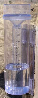
It goes back to the consistency aspect of collecting data. Not all rain gauges are created equal nor do they all report the same. The majority of automated rain gauges, when summed over several months or years, report less precipitation than actually fell, and sometimes by a significant amount -- sometimes 25% or more. Also, most automatic gauges cannot collect snow.
Because of these test results, CoCoRaHS asks the observers to set up a CoCoRaHS 4" gauge along with their automated gauge and see for themselves. Many observers have converted to using the 4" gauge as their daily measurement when they see the results, and then use their automated gauge as a backup when they are gone. As a sidenote, This station uses both. Once the 4" gauge is read and compared to the electronic gauge any adjustments, if required, submitted by the electronic gauge's report is entered in manually to the weather data collection software so this site reports truly accurate readings.
Who is sponsoring this network?
The National Oceanic and Atmospheric Administration (NOAA) is a major sponsor of CoCoRaHS. Other organizations have contributed either financially, and/or with supplies and equipment. Our list of sponsors continues to grow. Many other organizations and individuals have pitched in time and resources to help keep the network up and running. We are grateful to all of you, as CoCoRaHS would not be possible without your help.
What benefits are there in volunteering?
 One of the neat things about participating in this network is coming away with the feeling that you have made an important contribution that helps others.
By providing your daily observation, you help to fill in a piece of the weather puzzle that affects many across your area in one way or another. You also
will have the chance to make some new friends as you do something important and learn some new things along the way. In some areas, activities are organized
for network participants including training sessions, field trips, special speakers, picnics, pot-luck dinners, and photography contests just to name a few.
One of the neat things about participating in this network is coming away with the feeling that you have made an important contribution that helps others.
By providing your daily observation, you help to fill in a piece of the weather puzzle that affects many across your area in one way or another. You also
will have the chance to make some new friends as you do something important and learn some new things along the way. In some areas, activities are organized
for network participants including training sessions, field trips, special speakers, picnics, pot-luck dinners, and photography contests just to name a few.How can I sign up?
Just click here to sign up as a CoCoRaHS Volunteer Observer or download a .pdf version of our application and return it as soon as possible.
For the current precipitation CoCoRaHS map of Carroll County, TN click here.

