


About this Station |
This station came online 11 October 2008 in our original location of Uniontown, PA. and was powered by a
LaCrosse Technologies WS-2308 weather station and later
upgraded to a Davis Vantage Pro2 Wireless (model 6162). The data is collected every 2 to 5 seconds with current weather
conditions, wind speed, wind direction, current temperature, dew point, humidity, barometric pressure, rainfall, solar
radiation & UV are updated almost instantly. The website is fully updated every 1-5 minutes including the NOAA NWS
Forecast and other less important weather data. Watches & Warnings for the Bruceton Area are checked every 3 minutes.
Station data history can also be viewed.
In September 2011, we retired the old LaCrosse Technologies weather station in lieu of a more superior quality and more precise measuring device by moving to a Davis Vantage Pro2 Wireless station. This station is considerably more accurate and reliable with little to no gaps in the data due to inferior equipment.
In August 2012 we decided to move south out of the snobbish northeast and to get away from the very prevalent northern attitude of "I am convinced I make more money than you, therefore I know I am better than you." It got boring and very obscene. So we bought our new house in the small town of Bruceton, TN., installed the station here and all information now is from that location.
This site data is collected and parsed using Weather Display Software. The weather station sends data to the VP2 console every 2.5 to 5 seconds which in turns reports same to the Weather Display software. This software compiles and then uploads current data to the website no less than every 10 seconds but no more than 5 minutes. Other data of less importance is uploaded every 1-5 minutes.
An Ultraviolet (UV) Sensor was installed and data recording began on 19 November 2012. Additionally a Solar Radiation sensor was installed and data recording began on 23 December 2012.
The station sits at an elevation of 491 Feet (149 Meters), at Lat: 36° 2' 4.4736" N (36.034576°), Lon: 88° 14' 38.3964" W (-88.243999°) in Carroll County about halfway between Memphis and Nashville but north of them. It is comprised of an anemometer (wind gauge), a rain gauge, a thermo-hygro sensor, a UV sensor and a Solar Radiation sensor along with a CoCoRaHS / NWS certified 4" manual rain gauge situated in optimal position for the highest accuracy possible.
The Hardware |
The weather server that runs all the weather software and that which the Davis VP2 is feed to is a HP Proliant DL585 Quad-Core server
with 24gig of RAM with five 1TB Western Digital drives in a RAID5 array, running Windows® 7 Professional and mounted into a server case.
The webcams are wirelessly connected and feed into a separate HP Proliant DL585 Quad-Core server with 16gig of RAM with five 1TB Western
Digital drives in a RAID5 array running Windows® Server 8 R2. iSPY software is being
used to bring you the webcam images.
The GRlevel3 radar server is a home-built Intel Dual Core Quad 2.66GHz processor with 8GB DDR3 RAM running Windows® 7 Professional. There are five 1TB Western Digital drives in a RAID5 array that helps overcome a single drive failure. That server also runs Windows® 7 Professional. The machine is administered and accessed via a Raritan Paragon II UMT832 KVM interface.
The network that supports the server as well as other machines on the network is a fully managed network powered by a TPlink switch with a 1Gbit uplink to all other layers within the network.
Why a Weather Station in Bruceton? |
 The National Weather Service updates the local Bruceton area weather based on data gathered at the
Jackson, McKellar-Sipes Regional Airport (METAR: KMKL) approximately 52 air miles southwest of Bruceton. Our data is based on the actual
Bruceton weather conditions, not an airport in another county, 52 miles away, where the temperatures can vary by as much as ±10°F.
The National Weather Service updates the local Bruceton area weather based on data gathered at the
Jackson, McKellar-Sipes Regional Airport (METAR: KMKL) approximately 52 air miles southwest of Bruceton. Our data is based on the actual
Bruceton weather conditions, not an airport in another county, 52 miles away, where the temperatures can vary by as much as ±10°F.
While not always true, advancements of weather (fronts) entering into this area generally move in from the SSW, NNW and W directions. Due to the local terrain, mainly the Mississippi and Tennessee Rivers, weather fronts crossing this area rarely move north to south but the reverse is more common. If the weather is moving in a easterly direction the weather in Bruceton changes (or catches up) after the closest reporting airport (KMKL) by as much as 1-2 hours time, if at all. The same holds true if weather fronts are moving northward from a southerly direction, the airport's weather changes prior to Bruceton. It is very common for KMKL to be reporting precipitation yet our location is sunshine, with no precipitation at that time nor expected in the immediate future. Other variances like rainfall, snowfall, cloud cover, wind, etc. can vary greatly between the airport and where our weather station is located.
There are many occasions when a weather front begins moving into the area that contains precipitation and radar indicates there is no way we will escape yet, the precipitation will just "disappear" prior to arriving to our location then on many occasions re-forms or even intensifies just after crossing out of the area.
There are a total of 3 NWS radar facilities within range of our station. KNQA (Memphis, TN), KOHX (Nashville, TN) & KPAH (Paducah, KY). There also is a military weather radar site in Fort Campbell, KY (KHPX), Any of these radars would give an accurate picture of the radar in the Bruceton, TN. area. We choose to use the KPAH and KNQA radars for our GRLevel3 Radar site since most of the incoming weather arrives from the west but we can and do occasionally switch to either KHPX or KOHX as weather fronts and patterns dictate.
We are a trained SkyWarn Spotter Observer and this station is part of the SkyWarn Spotter program. SkyWarn is a voluntary program in which the pubic can participate and interact with your local NWS Office. Skywarn spotters are encouraged to relay critical weather information to their local NWS Office, in support of the Warning and Forecast Operations. The information SkyWarn Spotters provide routinely helps the NWS Forecasters make better/more informed forecasts, and helps them to warn others earlier of impending weather related dangers or hazards.
Precipitation reports are submitted to CoCoRaHS. Precipitation as well as all other weather data is reported to CWOP. CWOP is a mesonet provider to MADIS (Meteorological Assimilation Data Ingest System). MADIS then provides data to NOAA to aid them in both the climatology of the local area as well as assisting in issuing earlier warnings of severe weather. It also assists in producing forecast and outlooks for future weather. As an example, wind speed and direction data could prove useful information to Emergency Management officials or to Homeland Security in the event of a chemical spill or terrorist incidents.
Currently, Bruceton weather data is shared with:
- Weather Underground (KTNBRUCE2)
- Citizen Weather Observer Program (CWOP) as Station ID: AT066 and through CWOP/APRSWXNET to:
- NOAA MESONET (AT066)
- NOAA MADIS (AT066)
About Bruceton |
 Bruceton, Tennessee is located in east-central Carroll County very close to the Carroll/Benton County line and encompasses a total
of 1.9 square miles alongside the Big Sandy River. The population was 1,478 at the 2010 census. The only main access to Bruceton
is via US-70 arriving from the east or the west. Bruceton is located approximately 12 miles ENE of Huntingdon, TN, the
Carroll County Seat.
Bruceton, Tennessee is located in east-central Carroll County very close to the Carroll/Benton County line and encompasses a total
of 1.9 square miles alongside the Big Sandy River. The population was 1,478 at the 2010 census. The only main access to Bruceton
is via US-70 arriving from the east or the west. Bruceton is located approximately 12 miles ENE of Huntingdon, TN, the
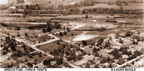
Carroll County Seat.The area that is now Bruceton was first known as Hollow Rock Junction and was known as so until 1921 when railroad officials chose Hollow Rock Junction as the central location for terminals in Lexington, Paducah and Martin. The Post Office was established on 7 July 1922 with Sarah M. Boyd as the first Postmaster. In order to give the post office a name, it was dubbed New One and operated under that name until 15 January 1923 when the name was changed to Junction City due to Nashville, Chattanooga & St. Louis Railway's presence. In 1928, a group of citizens that wanted to honor W.P. Bruce, then the General Manager of the NC&StL railroad and a tremendous contributor to the community's developmental progress, requested and received a charter that incorporated the town as Bruceton. Kirk Hogan was the first mayor of Bruceton. It is rumored that the older generation of Hollow Rock citizens have never forgiven the railroad for moving a mile down the track to build their yard.
N.C. & St. L Railroad Company formed the Tennessee Property Company in order to offer affordable housing to railroad workers, their families, and also, with the hopes of attracting future residents. The TPC obtained land from local residents and subdivided it which provided more affordable real estate to those interested in settling in Bruceton. This effort attracted many to the area, and Bruceton was beginning to prosper as a railroad junction.
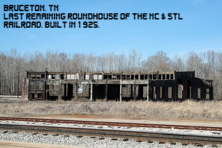 The roundhouse in Bruceton is a testament to the business that once thrived around the railroad. The original wooden
roundhouse, built in 1921, was completely destroyed by fire on November 21, 1924. In early 1925, a concrete roundhouse was
constructed to replace it. Although it has been abandoned for quite some time, the roundhouse remains a gigantic presence
that stands as a reminder of times past.
The roundhouse in Bruceton is a testament to the business that once thrived around the railroad. The original wooden
roundhouse, built in 1921, was completely destroyed by fire on November 21, 1924. In early 1925, a concrete roundhouse was
constructed to replace it. Although it has been abandoned for quite some time, the roundhouse remains a gigantic presence
that stands as a reminder of times past.Initially, there were no educational facilities located in the town of Bruceton. Children were either sent to boarding school in another town or to a neighboring town to attend public or private school. In later years, and old coach provided by the railroad was used as a classroom. A new school building was erected to serve rural students, and those meeting in the old coach were then transferred to this building. The Bruceton Elementary School was built in the early 1920's and the High School, now known as Central High, was built in 1937.
During the time of the depression, many railroad jobs were terminated which was a serious blow to the economic health of Bruceton. The railroad was the town's only source of financial gain at the time which meant that the people needed to develop an alternate source. The citizens raised enough money to build a factory with the hopes of luring industry into town. The town would not accept just anyone; the new owner would have to agree to use local labor. Henry I. Siegel Company purchased the 422,087 sq. ft. building in the 1930's and replenished the town's economic stamina by becoming the largest employer in Bruceton and Carroll County and one of the top ten employers in all of west Tennessee.
The company was founded in New York in 1923 as "Honesdale Manufacturing Co." by Henry I. Siegel from Lublin. The business concept of the company was the production of sturdy work clothes for plantation workers to be worn during the cotton harvest in Tennessee. Production of the jeans clothing, whose cotton was from three of the company's own plantations, also located in Bruceton. All products produced by the company in their various 12 manufacturing facilities shipped their product to Bruceton via their own fleet of trucks where all were washed, pressed, warehoused and distributed to their customers. Products brands included H.I.S., Chic as well as Chic Kids and Sunset Brands. Thanks to the workmanship and the stabile quality of his jeans products, Siegel also became the supplier of the US Army, for which he provided sturdy combat jackets during World War II.
Then Chairman and CEO Burton M. Rosenberg warned attendees at the company's March 1996 annual meeting that "it's going to be a very, very difficult year ... the type of year where you hunker down and strengthen your balance sheet in order to be there when the turn comes. If you have a good brand, it will eventually pay off." Rosenberg's "hunker down" strategy included the closure of several factories in Tennessee and Kentucky and the elimination of over one-fifth of Chic's workforce. And in a striking departure from its longstanding devotion to domestic manufacturing, the company took a $30 million charge to move production to Mexico. The Bruceton plant permanently closed its doors on 16 May 2002. The company is now known as Durango Apparel, Inc.
Geography |
The city center of Bruceton is located at 88°14'42" W and 36°2'14" N.
According to the United States Census Bureau, the town has a total area of 1.9 square miles (4.9 km²) and none of it is covered with water. The population as of 2010 was 1,478 persons.
The city is 472 feet (304 meters) above mean sea level. The main path and access to and through Bruceton is via US 70.
About this Website |
This site is a heavily modified version of the initial design template by CarterLake.org with PHP
conversion by Saratoga-Weather.org and heavily modified to it's present look by the
Webmaster of this site.
- Special thanks go to Kevin Reed at TNET Weather for his work on the original Carterlake templates, and his design for the common website PHP management.
- Special thanks to Mike Challis of Long Beach WA. for his wind-rose generator, Theme Switcher and CSS styling help with these templates.
- Special thanks go to Ken True of Saratoga-Weather.org for the AJAX conditions display, dashboard and integration of the TNET Weather common PHP site design for this site.
- Special thanks goes out to Bashewa Weather for the Cloud Base graphic code snippet as shown on the index page of the website.
- Template is originally based on Designs by Haran.
- This template is XHTML 1.0 compliant. Validate the XHTML and CSS of this page.

