


Weather Symbols |
Graphic intensive page. Please be patient while page loads.
Following are the 100 present weather symbols used in meteorology. They are divided into groups as indicated below.
Weather Symbol Grouping
|
||
| 00 | 01 | 02 | 03 | 04 | 05 | 06 |
|---|---|---|---|---|---|---|
 Cloud development NOT observed or NOT observable during past hour (not plotted). |
 Clouds generally dissolving or becoming less developed during past hour (not plotted). |
 State of sky on the whole unchanged during past hour (not plotted). |
 Clouds generally forming or developing during past hour (not plotted). |
 Visibility reduced by smoke |
 Haze |
 Widespread dust in suspension in the air, not raised by wind at or near the station at the time of observation |
| 07 | 08 | 09 | 10 | 11 | 12 | 13 |
|---|---|---|---|---|---|---|
 Dust or sand raised by the wind at or near the station at the time of the observation, but no well-developed dust whirl(s), and no sandstorm seen: or, in the case of ships, blowing spray at the station. |
 Well developed dust whirl(s) or sand whirl(s) seen at or near the station during the preceding hour or at the time of observation, but no duststorm or sandstorm. |
 Duststorm or sandstorm within sight at the time of observation, or at the station during the preceding hour. |
 Mist. |
 Patches of shallow fog at station, NOT deeper than 6 feet on land. |
 More or less continuous shallow fog at station, NOT deeper than 6 feet on land. |
 Lighting visible, no thunder heard. |
| 14 | 15 | 16 | 17 | 18 | 19 | 20 |
|---|---|---|---|---|---|---|
 Precipitation within sight, but NOT reaching the ground. |
 Precipitation within sight, reaching ground or the surface of the sea, but distant, i.e. estimated to be more than 3 miles from the station. |
 Precipitation within sight, reaching the ground or the surface of the sea, near to (within 3 miles), but not at the station. |
 Thunder heard, but no precipitation at the station. |
 Squall(s) within sight during past hour. |
 Funnel cloud(s) / Tornado(s) during the preceding hour or at time of observation. |
 Drizzle (not freezing) or snow grains not falling as shower(s) ended in the past hour. |
| 21 | 22 | 23 | 24 | 25 | 26 | 27 |
|---|---|---|---|---|---|---|
 Rain (not freezing) not falling as shower(s) ended in the past hour. |
 Snow not falling as shower(s) ended in the past hour. |
 Rain and snow or ice pellets not falling as shower(s) ended in the past hour. |
 Freezing drizzle or freezing rain not falling as shower(s) ended in the past hour. |
 Shower(s) of rain ended in the past hour. |
 Shower(s) of snow, or of rain and snow ended in the past hour. |
 Shower(s) of hail, or of rain and hail ended in the past hour. |
| 28 | 29 | 30 | 31 | 32 | 33 | 34 |
|---|---|---|---|---|---|---|
 Fog or ice fog ended in the past hour. |
 Thunderstorm (with or without precipitation) ended in the past hour. |
 Slight or moderate duststorm or sandstorm (has decreased during the preceding hour). |
 Slight or moderate duststorm or sandstorm (no appreciable change during the preceding hour). |
 Slight or moderate duststorm or sandstorm (has begun or increased during the preceding hour). |
 Severe duststorm or sandstorm has decreased during the preceding hour. |
 Severe duststorm or sandstorm has no appreciable change during the preceding hour. |
| 35 | 36 | 37 | 38 | 39 | 40 | 41 |
|---|---|---|---|---|---|---|
 Severe duststorm or sandstorm has begun or increased during the preceding hour. |
 Slight or moderate drifting snow (generally below eye level). |
 Heavy drifting snow (generally below eye level). |
 Slight or moderate blowing snow (generally above eye level). |
 Heavy drifting snow (generally above eye level). |
 Fog at a distance at the time of observation, but not at the station during the preceding hour, the fog or ice fog extending to a level above that of the observer. |
 Fog in patches. |
| 42 | 43 | 44 | 45 | 46 | 47 | 48 |
|---|---|---|---|---|---|---|
 Fog sky visible (has become thinner during preceding hour). |
 Fog sky obscured (has become thinner during preceding hour). |
 Fog sky visible (no appreciable change during the preceding hour). |
 Fog sky obscured (no appreciable change during the preceding hour). |
 Fog sky visible (has begun or has become thicker during the preceding hour). |
 Fog sky obscured (has begun or has become thicker during the preceding hour). |
 Fog, depositing rime ice, sky visible. |
| 49 | 50 | 51 | 52 | 53 | 54 | 55 |
|---|---|---|---|---|---|---|
 Fog, depositing rime ice, or ice fog, sky obscured. |
 Drizzle, not freezing, intermittent (slight at time of observation). |
 Drizzle, not freezing, continuous (slight at time of observation). |
 Drizzle, not freezing, intermittent (moderate at time of observation). |
 Drizzle, not freezing, continuous (moderate at time of observation). |
 Drizzle, not freezing, intermittent (heavy at time of observation). |
 Drizzle, not freezing, continuous (heavy at time of observation). |
| 56 | 57 | 58 | 59 | 60 | 61 | 62 |
|---|---|---|---|---|---|---|
 Drizzle, freezing, slight. |
 Drizzle, freezing, moderate or heavy. |
 Drizzle and rain, slight. |
 Drizzle and rain, moderate or heavy. |
 Rain, not freezing, intermittent (slight at time of observation). |
 Rain, not freezing, continuous (slight at time of observation). |
 Rain, not freezing, intermittent (moderate at time of observation). |
| 63 | 64 | 65 | 66 | 67 | 68 |
|---|---|---|---|---|---|
 Rain, not freezing, continuous (moderate at time of observation). |
 Rain, not freezing, intermittent (heavy at time of observation). |
 Rain, not freezing, continuous (heavy at time of observation). |
 Rain, freezing, slight. |
 Rain, freezing, moderate or heavy. |
 Rain or drizzle and snow, slight. |
| 69 | 70 | 71 | 72 | 73 | 74 | 75 |
|---|---|---|---|---|---|---|
 Rain or drizzle and snow, moderate or heavy. |
 Intermittent fall of snowflakes (slight at time of observation). |
 Continuous fall of snowflakes (slight at time of observation). |
 Intermittent fall of snowflakes (moderate at time of observation). |
 Continuous fall of snowflakes (moderate at time of observation). |
 Intermittent fall of snowflakes (heavy at time of observation). |
 Continuous fall of snowflakes (heavy at time of observation). |
| 76 | 77 | 78 | 79 | 80 | 81 | 82 |
|---|---|---|---|---|---|---|
 Ice needles (with or without fog). |
 Snow grains (with or without fog). |
 Isolated star-like snow crystals (with or without fog). |
 Ice pellets (sleet). |
 Rain shower(s), slight. |
 Rain shower(s), moderate or heavy. |
 Rain shower(s), violent. |
| 83 | 84 | 85 | 86 | 87 | 88 |
|---|---|---|---|---|---|
 Shower(s) of rain and snow mixed, slight. |
 Shower(s) of rain and snow mixed, moderate or heavy. |
 Snow shower(s), slight. |
 Snow shower(s), moderate or heavy. |
 Shower(s) of snow pellets or small hail, slight with or without rain or rain and snow mixed. |
 Shower(s) of snow pellets or small hail, moderate or heavy with or without rain or rain and snow mixed. |
| 89 | 90 | 91 | 92 | 93 | 94 | 95 |
|---|---|---|---|---|---|---|
 Shower(s) of hail, with or without rain or rain and snow mixed, not associated with thunder, slight. |
 Shower(s) of hail, with or without rain or rain and snow mixed, not associated with thunder, moderate or heavy. |
 Thunder- storm during the pre- ceeding hour but not at time of observation with slight rain at time of observation. |
 Thunder- storm during the pre- ceeding hour but not at time of observation with moderate or heavy rain at time of observation. |
 Thunder- storm during the pre- ceeding hour but not at time of observation with slight snow, or rain and snow mixed, or hail at time of observation. |
 Thunder- storm during the pre- ceeding hour but not at time of observation with moderate or heavy snow, or rain and snow mixed, or hail at time of observation. |
 Thunder- storm, slight or moderate, without hail but with rain and or snow at time of observation. |
| 96 | 97 | 98 | 99 | |||
|---|---|---|---|---|---|---|
 Thunder- storm, slight or moderate, with hail at time of observation. |
 Thunder- storm, heavy, without hail but with rain and or snow at time of observation. |
 Thunder- storm combined with duststorm or sandstorm at time of observation. |
 Thunder- storm, heavy, with hail at time of observation. |
Cloud Symbol Priority |
| High-level Clouds | H9 |
H7 |
H8 |
H6 |
H5 |
H4 |
H3 |
H2 |
H1 |
|---|---|---|---|---|---|---|---|---|---|
| Mid-level Clouds | M9 |
M8 |
M7 |
M6 |
M5 |
M4 |
M3 |
M2 |
M1 |
| Low-level Clouds | L9 |
L3 |
L4 |
L8 |
L2 |
L1 |
L5 |
L6 |
L7 |
Often, more than one cloud type occurs in each level (low, middle, or high) in the atmosphere. However, since only one cloud type is indicated for each level, the cloud that is coded is based upon a priority list of the most predominate cloud for each particular level.
At right is a list of priority and symbol for each cloud type. Hold mouse over symbols to reveal cloud type name.
How is this list used? If more than one cloud type exits for any given level, the cloud with the highest priority is plotted. For example, an observer might see a cumulonimbus (L9) and stratocumulus (L5) at the same time. In the list of priorities, only the cumulonimbus (L9) will be plotted.
Pressure Tendency Symbols |
| Code | Symbol | Description | |
|---|---|---|---|
| Pressure is higher than three hours ago. |
0 | Rising, the falling | |
| 1 | Rising, then steady; or rising, then rising more slowly. | ||
| 2 | Rising steadily, or unsteadily. | ||
| 3 | Falling or steady, then rising; or rising, then rising more quickly. | ||
| Pressure is the same as three hours ago. |
4 | Steady, same as 3 hours ago. | |
| Pressure is lower than three hours ago. |
5 | Falling, then rising, same or lower than 3 hours ago. | |
| 6 | Falling, then steady; or falling, then falling more slowly. | ||
| 7 | Falling steadily, or unsteadily. | ||
| 8 | Steady or rising, then falling; or falling, then falling more quickly. |
These symbols show the pressure trend during the past three hours. It is useful for determining motion of front. For example, a typical pressure pattern for a cold front that has passed a station would be code 3, falling or steady, then rising; or rising, then rising more quickly.
The steady or falling pressure will be the change in pressure before the front passes over the location. After frontal passage, higher pressure moves over the station as indicated by the pressure rising more quickly.
Sky Cover Symbols |
These are the ten symbols that represent the total amount of sky cover at the time of the observation (reported in eigths).
| No Clouds |
1/8ths Skycover |
2/8ths Skycover |
3/8ths Skycover |
4/8ths Skycover |
5/8ths Skycover |
6/8ths Skycover |
7/8ths Skycover |
8/8ths Skycover (completely overcast) |
Sky Obscured (used when a surface-based weather phenomena (i.e. fog, dust, etc.) blocks the view of the sky) |
Wind Speed & Direction |
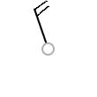
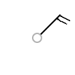
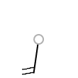
Wind speed. A combination of long/short barbs and pennants indicate the speed of the wind in station weather plots rounded to the nearest 5 knots. Calm wind is indicated by a large circle drawn around the skycover symbol.
One long barb is used to indicate each 10 knots with the short barb representing 5 knots. At 50 knots, the barbs changes to a pennant. For wind speeds higher than 50 knots, long and short barbs are used again in combination with the pennant(s). (See examples below.)
| Observed Wind Speed |
0-2 kts (0-2 mph) |
3-7 kts (3-8 mph) |
8-12 kts (9-14 mph) |
13-17 kts (15-20 mph) |
18-22 kts (21-25 mph) |
23-27 kts (26-31 mph) |
|---|---|---|---|---|---|---|
| Rounded to the nearest 5 |
0 kts | 5 kts | 10 kts | 15 kts | 20 kts | 25 kts |
| Plotted as: |  |
 |
 |
 |
 |
 |
| Observed Wind Speed |
28-32 kts (32-37 mph) |
33-37 kts (38-43 mph) |
48-52 kts (55-60 mph) |
53-57 kts (61-66 mph) |
58-62 kts (67-71 mph) |
63-67 kts (73-77 mph) |
|---|---|---|---|---|---|---|
| Rounded to the nearest 5 |
30 kts | 35 kts | 50 kts | 55 kts | 60 kts | 65 kts |
| Plotted as: |  |
 |
 |
 |
 |
 |
| Observed Wind Speed |
98-102 kts (113-117 mph) |
102-107 kts (119-123 mph) |
|---|---|---|
| Rounded to the nearest 5 |
100 kts | 105 kts |
| Plotted as: |  |
 |
| Wind FROM 340° (NNW) |
Wind FROM 040° (NE) |
Wind FROM 190° (S) |
|---|---|---|
 |
 |
 |
The wind direction is indicated by the long shaft. The shaft will point to the direction FROM which the wind is blowing. The direction is based upon a 36-point compass.
Past 6-Hr. Weather Symbols |
| 0 | 1 | 2 | 3 | 4 | 5 | 6 | 7 | 8 | 9 |
|---|---|---|---|---|---|---|---|---|---|
 Clear or Few Clouds (not plotted). |
Partly cloudy (scattered) or variable sky (not plotted). |
Cloudy (broken) or overcast (not plotted). |
Sandstorm or dust storm, or drifting or blowing snow. |
Fog, or smoke, or thick dust haze. |
Drizzle. |
Rain. |
Snow, or rain and snow mixed, or ice pellets (sleet). |
 Shower(s). |
Thunderstorm, with or without precipitation. |

