


Understanding How Thunderstorms and Snow Storms Develop |
Life Cycle of a Thunderstorm
Warm air has a lower density than cool air, so warm air rises within cooler air, similar to hot air balloons. Clouds form as warm air carrying moisture rises within cooler air. As the warm air rises, it cools. The moist water vapor begins to condense. When the moisture condenses, this releases energy that keeps the air warmer than its surroundings, so that it continues to rise. If enough instability is present in the atmosphere, this process will continue long enough for cumulonimbus clouds to form, which support lightning and thunder.
All thunderstorms, regardless of type, go through three stages: the cumulus stage, the mature stage, and the dissipation stage. Depending on the conditions present in the atmosphere, these three stages can take anywhere from 20 minutes to several hours to occur.
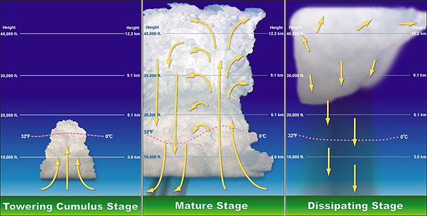
Airflow diagrams showing three stages of a thunderstorm life cycle.
Cumulus Stage
The first stage of a thunderstorm is the cumulus stage, or developing stage. In this stage, masses of moisture are lifted upwards into the atmosphere. The trigger for this lift can be insolation heating the ground producing thermals, areas where two winds converge forcing air upwards, or where winds blow over terrain of increasing elevation. The moisture rapidly cools into liquid drops of water, which appears as cumulus clouds. As the water vapor condenses into liquid, latent heat is released which warms the air, causing it to become less dense than the surrounding dry air. The air tends to rise in an updraft through the process of convection (hence the term convective precipitation). This creates a low-pressure zone beneath the forming thunderstorm. In a typical thunderstorm, approximately 5Ã108 kg of water vapor are lifted, and the amount of energy released when this condenses is about equal to the energy used by a city (US-2002) of 100,000 during a month.
Mature Stage
In the mature stage of a thunderstorm, the warmed air continues to rise until it reaches existing air which is warmer, and the air can rise no further. Often this 'cap' is the tropopause. The air is instead forced to spread out, giving the storm a characteristic anvil shape. The resulting cloud is called cumulonimbus incus. The water droplets coalesce into heavy droplets and freeze to become ice particles. As these fall they melt to become rain. If the updraft is strong enough, the droplets are held aloft long enough to be so large that they do not melt completely and fall as hail. While updrafts are still present, the falling rain creates downdrafts as well. The simultaneous presence of both an updraft and downdrafts marks the mature stage of the storm, and during this stage considerable internal turbulence can occur in the storm system, which sometimes manifests as strong winds, severe lightning, and even tornadoes.
Typically, if there is little wind shear, the storm will rapidly enter the dissipating stage and 'rain itself out', but if there is sufficient change in wind speed and/or direction the downdraft will be separated from the updraft, and the storm may become a supercell, and the mature stage can sustain itself for several hours.
In certain cases however, even with little wind shear, if there is enough atmospheric support and instability in place for the thunderstorm to feed on, it may even maintain its mature stage a bit longer than most storms.
Dissipating Stage
If atmospheric conditions do not support super cellular development, this stage occurs rather quickly, approximately 20-30 minutes into the life of the thunderstorm. The downdraft will push down out of the thunderstorm, hit the ground and spread out. The cool air carried to the ground by the downdraft cuts off the inflow of the thunderstorm, the updraft disappears and the thunderstorm will dissipate.
All thunderstorms, severe or not, must have three conditions present in order to develop. The first necessary condition is moisture in the lower and mid levels of the atmosphere. As air rises in a thunderstorm updraft, moisture condenses into small water drop which form clouds (and eventually precipitation). When the moisture condenses, heat is released into the air, making it warmer and less dense than its surroundings. The added heat allows the air in the updraft to continue rising.
The second necessary condition is instability. If the airmass is unstable, air which is pushed upward by some force will continue upward. An unstable airmass usually contains relatively warm (and usually moist) air near the surface and relatively cold (and usually dry) air in the mid and upper levels of the atmosphere. As the low-level air rises in an updraft, it becomes less dense than the surrounding air and continues to rise. This process is often augmented by added heat due to condensation as discussed above. The air will continue to move upward until it becomes colder and more dense than its surroundings.
The third necessary condition is a source of lift. Lift is a mechanism for starting an updraft in a moist, unstable airmass. The lifting source can take on several forms. The most common is differential heating. As the sun heats the earth's surface, portions of the surface (and the air just above it) will warm more readily than the nearby areas. These "warm pockets" are less dense than the surrounding air and will rise. If the air has sufficient moisture and is unstable, a thunderstorm may form.
The source of lift may also be mechanical in nature. Moist air flowing up the side of a mountain may reach a point where it is less dense than its environment, and thunderstorms may develop. This is common on the eastern slopes of the Rocky Mountains during the summer. Advancing cold fronts, warm fronts, outflow boundaries, drylines, and sea breeze fronts also act as triggers by lifting moist, low-level air to the point where it is warmer and less dense than its environment at which time storms can form.
Recent research has found that if the environment (wind, moisture, instability) of a storm is changed, then the type of storm (multicell, supercell, etc.) which is favored to exist may change as well.
The amount of vertical wind shear is the storm's environment is critical in determining what type of storm will form. Vertical wind shear is defined as a change in wind direction or speed with height. If the amount of vertical shear is low (little change in wind speed or direction with altitude) then multicellular storms with short lived updrafts will be favored. Low values of vertical wind shear result in weak inflow to a storm. Because the inflow is weak, the outflow from the rainy downdraft area will push the gust front out away from the storm. This, in turn, will cut off the storm's source of warm, moist, unstable air, resulting in a storm with short lived updrafts. Precipitation which is produced will fall through the storm's updraft and contribute to the updraft being short lived.
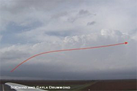 As vertical wind shear increases, storms with longer lived updrafts will be favored. Stronger vertical wind shear results in stronger inflow to
the storm. The gust front will be held close to the storm, and the storm will have access to the source of warm, moist air for a much longer
time. As a result, the storm's updraft will tend to last longer when the environment has strong vertical wind shear. Precipitation will tend to
fall downwind from the updraft rather than through the updraft. This enables the updraft to continue for relatively long periods of time. The
picture to the left shows a storm which has developed in a high shear environment.
As vertical wind shear increases, storms with longer lived updrafts will be favored. Stronger vertical wind shear results in stronger inflow to
the storm. The gust front will be held close to the storm, and the storm will have access to the source of warm, moist air for a much longer
time. As a result, the storm's updraft will tend to last longer when the environment has strong vertical wind shear. Precipitation will tend to
fall downwind from the updraft rather than through the updraft. This enables the updraft to continue for relatively long periods of time. The
picture to the left shows a storm which has developed in a high shear environment.
Closely related to the concept of vertical wind shear is the veering of the wind with height in the lowest mile or so of the atmosphere. Veering is defined as a clockwise turning of the wind direction as we move up through the atmosphere. It is possible to make a rough check of veering while spotting. If there are two layers of clouds in the lower levels of the atmosphere, look closely at which direction those cloud layers are moving. If the direction turns clockwise between the lower and upper layers, then veering is present.
Computer simulations and observational studies have suggested that veering of the low level wind is instrumental in the production of storm rotation. If the wind speed is sufficiently strong (usually 30 mph or greater) and veering of the wind with height is present, then horizontal "rolls" may develop in the lower levels of the atmosphere. These horizontal "rolls" may then be tilted into a vertically oriented rotation by a storm's updraft. The updraft can also "stretch" the vertical rotation and increase the rate of rotation. Once this vertical rotation has been established, a mesocyclone can develop which may produce a tornado or significant other weather.
Variations in moisture and instability can also have an effect on thunderstorms. If the amount of moisture in the atmosphere is low (as might be found on the High Plains), the storms will tend to have high cloud bases. Small amounts of precipitation will fall from these storms, but they will typically have strong downdrafts. If moisture levels in the atmosphere are high (as might be found in the Southeast), then storms will have low cloud bases. Copious amounts of precipitation will reach the ground usually accompanied by weak downdrafts. A rule of thumb to keep in mind is: the higher the cloud base, the better chance for dry microbursts. The lower the cloud base, the better the chance for flash flood producing rainfall.
The amount of instability which is present plays in important role in the strength of a thunderstorm's updraft and downdraft. If the instability is low, then a storm's drafts will probably not be strong enough to produce severe weather. If the storm's environment has high instability, then the storm's drafts will be stronger, and the storm will have a better chance or producing severe weather.
Another important factor in the storms environment, although not as critical as the above mentioned factors, is the presence of a mid level capping inversion. The mid level capping inversion is a thin layer of warm air between the low level moist air and the upper level (usually dry) air. If the mid-level cap is weak or is not present, then the storms will usually form early in the day before the sun's strong heating can produce high amounts of instability. A number of storms may form, but the storms will generally be weak and poorly organized. If the mid-level cap is strong, then storms will not form at all. The very warm mid-level temperatures will literally act as a lid, preventing updrafts from going above the cap.
A mid-level cap of moderate strength is preferred for the development of severe storms. A moderate cap will prevent weak storms from forming, thus "saving up" the atmosphere's instability. When storms do form, usually in the mid to late afternoon, only the strongest updrafts will be able to break the cap and continue to develop. These few storms can take advantage of the high instability which is present, with little competition from nearby storms, and possibly develop into severe storms.
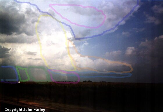 In the above picture, we are looking SE at the storm. Movement is from right to left, SW to NE. The direction the anvil is being swept
is always the general direction of movement of the storm. We are to the NW of the storm. The various elements outlined are color coded as
follows:
In the above picture, we are looking SE at the storm. Movement is from right to left, SW to NE. The direction the anvil is being swept
is always the general direction of movement of the storm. We are to the NW of the storm. The various elements outlined are color coded as
follows:
PURPLE area in the upper center/ this is the Backsheared anvil.
PINK area within the dark blue in the upper areas / this is where mammatus clouds are likely to be seen later
ORANGE area on the right side / this is the Flanking Line
YELLOW area in the middle / this is the main updraft area
BLUE box area near the bottom / this is the rain free base
PINK box near the bottom / this is the area to watch for wall cloud and tornado development. Note that this is directly below the main updraft area
DARK GREEN box / this is where large hail would be occurring
LIGHT GREEN box / this is where smaller hail would fall
BLUE box to the left / this is where the heaviest rain would fall. If we could see further to the left we would see the rain getting lighter and lighter.
Winter Storm Specifics
Just like any other storm at other times of the year, the right combination of ingredients is necessary for a winter storm to develop.
Three basic ingredients are necessary to make a winter storm:
Warm air has a lower density than cool air, so warm air rises within cooler air, similar to hot air balloons. Clouds form as warm air carrying moisture rises within cooler air. As the warm air rises, it cools. The moist water vapor begins to condense. When the moisture condenses, this releases energy that keeps the air warmer than its surroundings, so that it continues to rise. If enough instability is present in the atmosphere, this process will continue long enough for cumulonimbus clouds to form, which support lightning and thunder.
All thunderstorms, regardless of type, go through three stages: the cumulus stage, the mature stage, and the dissipation stage. Depending on the conditions present in the atmosphere, these three stages can take anywhere from 20 minutes to several hours to occur.
Airflow diagrams showing three stages of a thunderstorm life cycle.
Cumulus Stage
The first stage of a thunderstorm is the cumulus stage, or developing stage. In this stage, masses of moisture are lifted upwards into the atmosphere. The trigger for this lift can be insolation heating the ground producing thermals, areas where two winds converge forcing air upwards, or where winds blow over terrain of increasing elevation. The moisture rapidly cools into liquid drops of water, which appears as cumulus clouds. As the water vapor condenses into liquid, latent heat is released which warms the air, causing it to become less dense than the surrounding dry air. The air tends to rise in an updraft through the process of convection (hence the term convective precipitation). This creates a low-pressure zone beneath the forming thunderstorm. In a typical thunderstorm, approximately 5Ã108 kg of water vapor are lifted, and the amount of energy released when this condenses is about equal to the energy used by a city (US-2002) of 100,000 during a month.
Mature Stage
In the mature stage of a thunderstorm, the warmed air continues to rise until it reaches existing air which is warmer, and the air can rise no further. Often this 'cap' is the tropopause. The air is instead forced to spread out, giving the storm a characteristic anvil shape. The resulting cloud is called cumulonimbus incus. The water droplets coalesce into heavy droplets and freeze to become ice particles. As these fall they melt to become rain. If the updraft is strong enough, the droplets are held aloft long enough to be so large that they do not melt completely and fall as hail. While updrafts are still present, the falling rain creates downdrafts as well. The simultaneous presence of both an updraft and downdrafts marks the mature stage of the storm, and during this stage considerable internal turbulence can occur in the storm system, which sometimes manifests as strong winds, severe lightning, and even tornadoes.
Typically, if there is little wind shear, the storm will rapidly enter the dissipating stage and 'rain itself out', but if there is sufficient change in wind speed and/or direction the downdraft will be separated from the updraft, and the storm may become a supercell, and the mature stage can sustain itself for several hours.
In certain cases however, even with little wind shear, if there is enough atmospheric support and instability in place for the thunderstorm to feed on, it may even maintain its mature stage a bit longer than most storms.
Dissipating Stage
If atmospheric conditions do not support super cellular development, this stage occurs rather quickly, approximately 20-30 minutes into the life of the thunderstorm. The downdraft will push down out of the thunderstorm, hit the ground and spread out. The cool air carried to the ground by the downdraft cuts off the inflow of the thunderstorm, the updraft disappears and the thunderstorm will dissipate.
In-Depth Explanation |
All thunderstorms, severe or not, must have three conditions present in order to develop. The first necessary condition is moisture in the lower and mid levels of the atmosphere. As air rises in a thunderstorm updraft, moisture condenses into small water drop which form clouds (and eventually precipitation). When the moisture condenses, heat is released into the air, making it warmer and less dense than its surroundings. The added heat allows the air in the updraft to continue rising.
The second necessary condition is instability. If the airmass is unstable, air which is pushed upward by some force will continue upward. An unstable airmass usually contains relatively warm (and usually moist) air near the surface and relatively cold (and usually dry) air in the mid and upper levels of the atmosphere. As the low-level air rises in an updraft, it becomes less dense than the surrounding air and continues to rise. This process is often augmented by added heat due to condensation as discussed above. The air will continue to move upward until it becomes colder and more dense than its surroundings.
The third necessary condition is a source of lift. Lift is a mechanism for starting an updraft in a moist, unstable airmass. The lifting source can take on several forms. The most common is differential heating. As the sun heats the earth's surface, portions of the surface (and the air just above it) will warm more readily than the nearby areas. These "warm pockets" are less dense than the surrounding air and will rise. If the air has sufficient moisture and is unstable, a thunderstorm may form.
The source of lift may also be mechanical in nature. Moist air flowing up the side of a mountain may reach a point where it is less dense than its environment, and thunderstorms may develop. This is common on the eastern slopes of the Rocky Mountains during the summer. Advancing cold fronts, warm fronts, outflow boundaries, drylines, and sea breeze fronts also act as triggers by lifting moist, low-level air to the point where it is warmer and less dense than its environment at which time storms can form.
Recent research has found that if the environment (wind, moisture, instability) of a storm is changed, then the type of storm (multicell, supercell, etc.) which is favored to exist may change as well.
The amount of vertical wind shear is the storm's environment is critical in determining what type of storm will form. Vertical wind shear is defined as a change in wind direction or speed with height. If the amount of vertical shear is low (little change in wind speed or direction with altitude) then multicellular storms with short lived updrafts will be favored. Low values of vertical wind shear result in weak inflow to a storm. Because the inflow is weak, the outflow from the rainy downdraft area will push the gust front out away from the storm. This, in turn, will cut off the storm's source of warm, moist, unstable air, resulting in a storm with short lived updrafts. Precipitation which is produced will fall through the storm's updraft and contribute to the updraft being short lived.
As vertical wind shear increases, storms with longer lived updrafts will be favored. Stronger vertical wind shear results in stronger inflow to
the storm. The gust front will be held close to the storm, and the storm will have access to the source of warm, moist air for a much longer
time. As a result, the storm's updraft will tend to last longer when the environment has strong vertical wind shear. Precipitation will tend to
fall downwind from the updraft rather than through the updraft. This enables the updraft to continue for relatively long periods of time. The
picture to the left shows a storm which has developed in a high shear environment.Closely related to the concept of vertical wind shear is the veering of the wind with height in the lowest mile or so of the atmosphere. Veering is defined as a clockwise turning of the wind direction as we move up through the atmosphere. It is possible to make a rough check of veering while spotting. If there are two layers of clouds in the lower levels of the atmosphere, look closely at which direction those cloud layers are moving. If the direction turns clockwise between the lower and upper layers, then veering is present.
Computer simulations and observational studies have suggested that veering of the low level wind is instrumental in the production of storm rotation. If the wind speed is sufficiently strong (usually 30 mph or greater) and veering of the wind with height is present, then horizontal "rolls" may develop in the lower levels of the atmosphere. These horizontal "rolls" may then be tilted into a vertically oriented rotation by a storm's updraft. The updraft can also "stretch" the vertical rotation and increase the rate of rotation. Once this vertical rotation has been established, a mesocyclone can develop which may produce a tornado or significant other weather.
Variations in moisture and instability can also have an effect on thunderstorms. If the amount of moisture in the atmosphere is low (as might be found on the High Plains), the storms will tend to have high cloud bases. Small amounts of precipitation will fall from these storms, but they will typically have strong downdrafts. If moisture levels in the atmosphere are high (as might be found in the Southeast), then storms will have low cloud bases. Copious amounts of precipitation will reach the ground usually accompanied by weak downdrafts. A rule of thumb to keep in mind is: the higher the cloud base, the better chance for dry microbursts. The lower the cloud base, the better the chance for flash flood producing rainfall.
The amount of instability which is present plays in important role in the strength of a thunderstorm's updraft and downdraft. If the instability is low, then a storm's drafts will probably not be strong enough to produce severe weather. If the storm's environment has high instability, then the storm's drafts will be stronger, and the storm will have a better chance or producing severe weather.
Another important factor in the storms environment, although not as critical as the above mentioned factors, is the presence of a mid level capping inversion. The mid level capping inversion is a thin layer of warm air between the low level moist air and the upper level (usually dry) air. If the mid-level cap is weak or is not present, then the storms will usually form early in the day before the sun's strong heating can produce high amounts of instability. A number of storms may form, but the storms will generally be weak and poorly organized. If the mid-level cap is strong, then storms will not form at all. The very warm mid-level temperatures will literally act as a lid, preventing updrafts from going above the cap.
A mid-level cap of moderate strength is preferred for the development of severe storms. A moderate cap will prevent weak storms from forming, thus "saving up" the atmosphere's instability. When storms do form, usually in the mid to late afternoon, only the strongest updrafts will be able to break the cap and continue to develop. These few storms can take advantage of the high instability which is present, with little competition from nearby storms, and possibly develop into severe storms.
PURPLE area in the upper center/ this is the Backsheared anvil.
PINK area within the dark blue in the upper areas / this is where mammatus clouds are likely to be seen later
ORANGE area on the right side / this is the Flanking Line
YELLOW area in the middle / this is the main updraft area
BLUE box area near the bottom / this is the rain free base
PINK box near the bottom / this is the area to watch for wall cloud and tornado development. Note that this is directly below the main updraft area
DARK GREEN box / this is where large hail would be occurring
LIGHT GREEN box / this is where smaller hail would fall
BLUE box to the left / this is where the heaviest rain would fall. If we could see further to the left we would see the rain getting lighter and lighter.
Winter Storm Specifics
Just like any other storm at other times of the year, the right combination of ingredients is necessary for a winter storm to develop.
Three basic ingredients are necessary to make a winter storm:
- Cold air. Below freezing temperatures in the clouds and near the ground are necessary to make snow and/or ice.
- Lift. Something to raise the moist air to form the clouds and cause precipitation. An example of lift is warm air colliding with cold air and being forced to rise over the cold dome. The boundary between the warm and cold air masses is called a front. Another example of lift is air flowing up a mountainside.
- Moisture. To form clouds and precipitation. Air blowing across a body of water, such as a large lake or the ocean, is an excellent source of moisture.

