


Monsoons Explained |
The word monsoon is derived from the Arabic word mausim, which means season. Traders plying the waters off the Arabian
and Indian coasts noted for centuries that dry northeast winds in the winter suddenly turn to the southwest during the summer,
and bring beneficial yet torrential rains to the Asian subcontinent. We now know that these large scale wind shifts, from
dry desert areas to moist tropical areas, occur in other parts of the Earth, including the Oceanic subcontinent, Southeast
Asia, Australia, North America, Africa and South America.
These wind shifts, and the dramatic change in weather they bring, are all more or less driven by a similar mechanism. For much of the year, low level winds in dry subtropical regions tend to blow from the land toward the sea. However by late spring, strong solar heating causes temperatures to soar over these land areas. The intense heat causes surface air pressure to fall, forming an area of low pressure known as a thermal low. Adjacent large bodies of water are also warmed, but not as quickly. Thus air pressures remain high relative to the land. Eventually, the pressure difference increases to the point that the cooler and much more humid air over the ocean is drawn toward the hot, dry air over land. This moist air moving onto the hot land eventually becomes unstable and develops into thunderstorms. Once this occurs and rain begins to fall, humidity levels increase over land, which only triggers more thunderstorms. This cycle will continue until land areas begin to cool in the early fall and water temperatures reach their peak in early fall. This reduces the pressure difference, which in turn causes the moist onshore flow to diminish, and the monsoon gradually ends.
Monsoon patterns also share a similar upper level flow characteristic. As surface low pressure forms over the hot land areas, the air in the upper levels of the atmosphere also sinks and warms. The sinking air aloft forms high pressure at jet stream level and causes upper level winds to weaken. The jet stream, which blows from west-to-east around the globe, is forced toward the poles as the upper level high expands. As the upper high migrates north, upper level temperatures south of the high cool slightly, while winds aloft over a monsoon region turn around to the east. These easterly winds aloft import considerable moisture off nearby oceans. When combined with the low level moisture, a favorable environment for thunderstorm development is created over areas that are typically dry for much of the year. As rain begins to fall, humidity levels increase over land, triggering more thunderstorms. This cycle continues until land areas cool in early fall and ocean water temperatures reach their peak. This reduces the pressure difference and the moist onshore flow, which in turn ends the monsoon.
Monsoons typically occur in areas with a large, elevated landmass which further enhances temperature and pressure contrasts between land and ocean, enhances moisture transport, and supports stronger subtropical highs. All of these, in turn, enhance rainfall in monsoon regions. This explains why the Indian Monsoon is the strongest and largest. The presence of the Tibetan Plateau, which resides to the north of the Indian subcontinent, is the largest and highest elevated landmass on Earth.
| The North American Monsoon | ||
Until the late 1970s, there was serious debate about whether a monsoon truly existed in North America. However, considerable
research, which culminated in the Southwest Arizona Monsoon Project (SWAMP) in 1990 and 1993, established the fact that a
bonafide monsoon, characterized by large-scale wind and rainfall shifts in the summer, develops over much of Mexico and the
intermountain region of the U.S. Published papers at the time called this pattern by different names, including the "Summer
Thunderstorm Season," "The Mexican Monsoon," "The Southwest Monsoon," and the "Arizona Monsoon."
In 2004, a major multinational research project was conducted in northwest Mexico and the southwest U.S. The North American Monsoon Experiment (NAME) sought to better describe the monsoon in North America, and increase our ability to predict it on a daily, weekly and seasonal basis. NAME showed that despite its many names, the weather pattern we see during the summer is not only a true monsoon, but it also affects the weather over a large portion of North America. Thus the generally accepted name is now "North American Monsoon."
 The North American Monsoon is not as strong or persistent as its Indian counterpart, mainly because the Mexican Plateau is
not as high or as large as the Tibetan Plateau in Asia. However, the North American Monsoon shares most of the basic
characteristics of its Indian counterpart. There is a shift in wind patterns in summer which occurs as Mexico and the
southwest U.S. warm under intense solar heating. As this happens, the flow reverses from dry land areas to moist ocean areas.
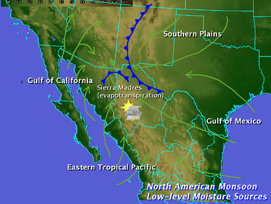
In the North American Monsoon, the low level moisture is transported primarily from the Gulf of California and eastern
Pacific. The Gulf of California, a narrow body of water surrounded by mountains, is particularly important for low-level
moisture transport into Arizona and Sonora. Upper level moisture is also transported into the region, mainly from the Gulf
of Mexico by easterly winds aloft. Once the forests of the Sierra Madre Occidental green up from the initial monsoon rains,
evaporation and plant transpiration can add additional moisture to the atmosphere which will then flow into Arizona. Finally,
if the southern Plains of the U.S. are unusually wet and green during the early summer months, that area can also serve as a
moisture source. This combination causes a distinct rainy season over large portions of western North America, which
develops rather quickly and sometimes dramatically. The image adjacent shows the general moisture sources for the North
American Monsoon.
The North American Monsoon is not as strong or persistent as its Indian counterpart, mainly because the Mexican Plateau is
not as high or as large as the Tibetan Plateau in Asia. However, the North American Monsoon shares most of the basic
characteristics of its Indian counterpart. There is a shift in wind patterns in summer which occurs as Mexico and the
southwest U.S. warm under intense solar heating. As this happens, the flow reverses from dry land areas to moist ocean areas.
In the North American Monsoon, the low level moisture is transported primarily from the Gulf of California and eastern
Pacific. The Gulf of California, a narrow body of water surrounded by mountains, is particularly important for low-level
moisture transport into Arizona and Sonora. Upper level moisture is also transported into the region, mainly from the Gulf
of Mexico by easterly winds aloft. Once the forests of the Sierra Madre Occidental green up from the initial monsoon rains,
evaporation and plant transpiration can add additional moisture to the atmosphere which will then flow into Arizona. Finally,
if the southern Plains of the U.S. are unusually wet and green during the early summer months, that area can also serve as a
moisture source. This combination causes a distinct rainy season over large portions of western North America, which
develops rather quickly and sometimes dramatically. The image adjacent shows the general moisture sources for the North
American Monsoon.
Rainfall during the monsoon is not continuous. It varies considerably, depending on a variety of factors. There are usually distinct "burst" periods of heavy rain during the monsoon, and "break" periods with little or no rain. Monsoon precipitation, however, accounts for a substantial portion of annual precipitation in northwest Mexico and the Southwest U.S. Most of these areas receive over half their annual precipitation from the monsoon.
The North American Monsoon circulation pattern typically develops in late May or early June over southwest Mexico. By mid to late summer, thunderstorms increase over the "core" region of the southwest U.S. and northwest Mexico, including the U.S. and Mexican states of Arizona, New Mexico, Sonora, Chihuahua, Sinaloa and Durango. The monsoon typically arrives in mid to late June over northwest Mexico, and early July over the southwest U.S. Once the monsoon is underway, mountain ranges, including the Sierra Madre Occidental and the Mogollon Rim provide a focusing mechanism for the daily development of thunderstorms. Thus much of the monsoon rainfall occurs in mountainous terrain. For example, monsoon rainfall in the Sierra Madre Occidental typically ranges from 10 to 15 inches. Since the southwest U.S. is at the northern fringe of the monsoon, precipitation is less and tends to be more variable. Areas further west of the core monsoon region, namely California and Baja California, typically receive only spotty monsoon-related rainfall. In those areas, the intense solar heating isn't strong enough to overcome a continual supply of cold water from the North Pacific Ocean moving down the west coast of North America. Winds do turn toward the land in these areas, but the cool moist air actually stabilizes the atmosphere.
In addition to the lower level monsoon circulation, an upper level monsoon (or subtropical) ridge develops over the southern High Plains and northern Mexico. In June, this ridge is too far south over Mexico and actually blocks deep moisture from moving north into Arizona.
However by late June or early July, this ridge shifts north into the southern Plains or southern Rockies. As this shift takes place, mid and upper level moisture streams into Arizona, and low level moisture surges from Mexico meet less resistance.
This monsoon ridge is almost as strong as the one which develops over Asia during the summer. However, since the lower level moisture flow is not as persistent as in the Indian monsoon, the upper level steering pattern and disturbances around the ridge are critical for influencing where thunderstorms develop on any given day. The exact strength and position of the subtropical ridge also governs how far north the tropical easterly winds aloft can spread. If the ridge is too close to a particular area, the sinking air at its center suppresses thunderstorms and can result in a significant monsoon "break." If the ridge is too far away or too weak, the east winds around the high are inadequate to bring tropical moisture into the mountains of Mexico and southwest U.S. However, if the ridge sets up in a few key locations, widespread and potentially severe thunderstorms can develop.
It is important to note that the monsoon is not an individual thunderstorm. While the word "monsoon" accurately conjures up images of torrential rains and flooding, calling a single thunderstorm a "monsoon" is incorrect. A monsoon is a large scale weather pattern which causes our summer thunderstorms.
In 2004, a major multinational research project was conducted in northwest Mexico and the southwest U.S. The North American Monsoon Experiment (NAME) sought to better describe the monsoon in North America, and increase our ability to predict it on a daily, weekly and seasonal basis. NAME showed that despite its many names, the weather pattern we see during the summer is not only a true monsoon, but it also affects the weather over a large portion of North America. Thus the generally accepted name is now "North American Monsoon."
The North American Monsoon is not as strong or persistent as its Indian counterpart, mainly because the Mexican Plateau is
not as high or as large as the Tibetan Plateau in Asia. However, the North American Monsoon shares most of the basic
characteristics of its Indian counterpart. There is a shift in wind patterns in summer which occurs as Mexico and the
southwest U.S. warm under intense solar heating. As this happens, the flow reverses from dry land areas to moist ocean areas.
In the North American Monsoon, the low level moisture is transported primarily from the Gulf of California and eastern
Pacific. The Gulf of California, a narrow body of water surrounded by mountains, is particularly important for low-level
moisture transport into Arizona and Sonora. Upper level moisture is also transported into the region, mainly from the Gulf
of Mexico by easterly winds aloft. Once the forests of the Sierra Madre Occidental green up from the initial monsoon rains,
evaporation and plant transpiration can add additional moisture to the atmosphere which will then flow into Arizona. Finally,
if the southern Plains of the U.S. are unusually wet and green during the early summer months, that area can also serve as a
moisture source. This combination causes a distinct rainy season over large portions of western North America, which
develops rather quickly and sometimes dramatically. The image adjacent shows the general moisture sources for the North
American Monsoon.Rainfall during the monsoon is not continuous. It varies considerably, depending on a variety of factors. There are usually distinct "burst" periods of heavy rain during the monsoon, and "break" periods with little or no rain. Monsoon precipitation, however, accounts for a substantial portion of annual precipitation in northwest Mexico and the Southwest U.S. Most of these areas receive over half their annual precipitation from the monsoon.
The North American Monsoon circulation pattern typically develops in late May or early June over southwest Mexico. By mid to late summer, thunderstorms increase over the "core" region of the southwest U.S. and northwest Mexico, including the U.S. and Mexican states of Arizona, New Mexico, Sonora, Chihuahua, Sinaloa and Durango. The monsoon typically arrives in mid to late June over northwest Mexico, and early July over the southwest U.S. Once the monsoon is underway, mountain ranges, including the Sierra Madre Occidental and the Mogollon Rim provide a focusing mechanism for the daily development of thunderstorms. Thus much of the monsoon rainfall occurs in mountainous terrain. For example, monsoon rainfall in the Sierra Madre Occidental typically ranges from 10 to 15 inches. Since the southwest U.S. is at the northern fringe of the monsoon, precipitation is less and tends to be more variable. Areas further west of the core monsoon region, namely California and Baja California, typically receive only spotty monsoon-related rainfall. In those areas, the intense solar heating isn't strong enough to overcome a continual supply of cold water from the North Pacific Ocean moving down the west coast of North America. Winds do turn toward the land in these areas, but the cool moist air actually stabilizes the atmosphere.
In addition to the lower level monsoon circulation, an upper level monsoon (or subtropical) ridge develops over the southern High Plains and northern Mexico. In June, this ridge is too far south over Mexico and actually blocks deep moisture from moving north into Arizona.
However by late June or early July, this ridge shifts north into the southern Plains or southern Rockies. As this shift takes place, mid and upper level moisture streams into Arizona, and low level moisture surges from Mexico meet less resistance.
This monsoon ridge is almost as strong as the one which develops over Asia during the summer. However, since the lower level moisture flow is not as persistent as in the Indian monsoon, the upper level steering pattern and disturbances around the ridge are critical for influencing where thunderstorms develop on any given day. The exact strength and position of the subtropical ridge also governs how far north the tropical easterly winds aloft can spread. If the ridge is too close to a particular area, the sinking air at its center suppresses thunderstorms and can result in a significant monsoon "break." If the ridge is too far away or too weak, the east winds around the high are inadequate to bring tropical moisture into the mountains of Mexico and southwest U.S. However, if the ridge sets up in a few key locations, widespread and potentially severe thunderstorms can develop.
It is important to note that the monsoon is not an individual thunderstorm. While the word "monsoon" accurately conjures up images of torrential rains and flooding, calling a single thunderstorm a "monsoon" is incorrect. A monsoon is a large scale weather pattern which causes our summer thunderstorms.

